Home > Europe > France > Maps
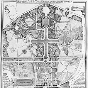
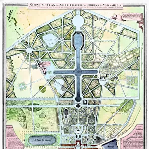
A New Plan of the Town, Chateau and Gardens of Versailles, 1714 (engraving)
")
![]()
Wall Art and Photo Gifts from Fine Art Finder
A New Plan of the Town, Chateau and Gardens of Versailles, 1714 (engraving)
741338 A New Plan of the Town, ChAteau and Gardens of Versailles, 1714 (engraving) by French School, (18th century); Bibliotheque Municipale, Versailles, France; (add.info.: Nouveau Plan des Ville, ChAteau et Jardins de Versailles; ); French, out of copyright
Media ID 23485702
© Bridgeman Images
Carte Cartography Designs Jardin Jardins Planning Versailles
FEATURES IN THESE COLLECTIONS
> Arts
> Art Movements
> Art Nouveau
> Fine Art Finder
> Artists
> French School
> Fine Art Finder
> Designs, Plans, Ceilings, Floors &
> Maps and Charts
> Related Images
EDITORS COMMENTS
This engraving, titled "A New Plan of the Town, Chateau and Gardens of Versailles" takes us back to the grandeur of 18th-century France. The print showcases a meticulously detailed map that offers a glimpse into the magnificent world of Versailles. The image transports us to an era when planning and design were at their finest. Every inch of this masterpiece is filled with intricate details, showcasing the meticulousness with which French architects approached their work. From the sprawling gardens to the majestic chateau, every element is carefully laid out in perfect harmony. As we examine this engraving closely, we can almost feel ourselves walking through those iconic gardens. The symmetrical patterns draw our eyes towards fountains and statues strategically placed throughout the landscape. We can imagine strolling along perfectly manicured paths lined with vibrant flowers and lush greenery. The town surrounding Versailles is also depicted in great detail on this print, giving us a sense of how it was integrated into this grand vision. Streets are neatly organized around squares and public spaces, creating an atmosphere that complements the elegance of its surroundings. This engraving not only serves as a historical document but also as a testament to human creativity and ingenuity. It reminds us that even centuries ago, people possessed remarkable skills in designing breathtaking landscapes that continue to inspire awe today.
MADE IN THE USA
Safe Shipping with 30 Day Money Back Guarantee
FREE PERSONALISATION*
We are proud to offer a range of customisation features including Personalised Captions, Color Filters and Picture Zoom Tools
FREE COLORIZATION SERVICE
You can choose advanced AI Colorization for this picture at no extra charge!
SECURE PAYMENTS
We happily accept a wide range of payment options so you can pay for the things you need in the way that is most convenient for you
* Options may vary by product and licensing agreement. Zoomed Pictures can be adjusted in the Cart.