Home > Arts > Artists > D > Fernao Vaz Dourado
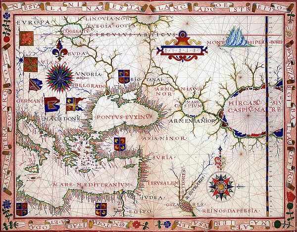
Map of the near east, 1570 (engraving)
![]()

Wall Art and Photo Gifts from Fine Art Finder
Map of the near east, 1570 (engraving)
2912265 Map of the near east, 1570 (engraving); (add.info.: Map of the near east by Fern£o Vaz Dourado (c. 1520 - c. 1580), a Portuguese cartographer of the sixteenth century. He belonged to the third period of the old Portuguese nautical cartography, which is characterised by the abandonment of Ptolemaic influence in the representation of the Orient and introduction of better accuracy in the depiction of lands and continents. Little is known about this historical figure, 1570.); Universal History Archive/UIG
Media ID 38316648
© Universal History Archive/UIG / Bridgeman Images
1570s Nautical Navigation Near East Orient Portuguese Ptolemaic
FEATURES IN THESE COLLECTIONS
> Arts
> Artists
> D
> Fernao Vaz Dourado
> Europe
> Portugal
> Related Images
> Fine Art Finder
> Artists
> Friedrich Perlberg
> Maps and Charts
> Early Maps
EDITORS COMMENTS
This stunning engraving of a Map of the near east from 1570 by Portuguese cartographer Fernão Vaz Dourado is a true masterpiece of sixteenth-century nautical cartography. Dourado, who belonged to the third period of old Portuguese nautical cartography, revolutionized the representation of the Orient by introducing greater accuracy in depicting lands and continents.
The intricate details and precision in this map showcase Dourado's skill and expertise in navigation and exploration. The abandonment of Ptolemaic influence in his work further highlights his innovative approach to mapping the world around him.
As we gaze upon this historical artifact, we are transported back in time to an era when maps were not just tools for navigation but works of art that captured the imagination of explorers and scholars alike. The rich history behind this map adds depth and significance to its portrayal of the near east during the late 16th century.
Through this print, we can appreciate Dourado's contribution to our understanding of geography and his legacy as one of Portugal's most renowned cartographers. This Map of the near east serves as a reminder of humanity's enduring quest for knowledge and discovery.
MADE IN THE USA
Safe Shipping with 30 Day Money Back Guarantee
FREE PERSONALISATION*
We are proud to offer a range of customisation features including Personalised Captions, Color Filters and Picture Zoom Tools
SECURE PAYMENTS
We happily accept a wide range of payment options so you can pay for the things you need in the way that is most convenient for you
* Options may vary by product and licensing agreement. Zoomed Pictures can be adjusted in the Cart.


