Home > Europe > France > Canton > Yonne
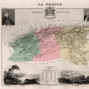
L Yonne (89), Burgundy - France and its Colonies. Atlas illustrates one hundred and five maps from the maps of the depot of war, bridges and footwear and the Navy by M. VUILLEMIN. 1876
, Burgundy - France and its Colonies. Atlas illustrates one hundred and five maps from the maps of the depot of war, bridges and footwear and the Navy by M. VUILLEMIN. 1876")
![]()
Wall Art and Photo Gifts from Fine Art Finder
L Yonne (89), Burgundy - France and its Colonies. Atlas illustrates one hundred and five maps from the maps of the depot of war, bridges and footwear and the Navy by M. VUILLEMIN. 1876
XEE4144412 L Yonne (89), Burgundy - France and its Colonies. Atlas illustrates one hundred and five maps from the maps of the depot of war, bridges and footwear and the Navy by M. VUILLEMIN. 1876. by Vuillemin, Alexandre (1812-1886); Private Collection; (add.info.: L Yonne (89), Burgundy - France and its Colonies. Atlas illustrates one hundred and five maps from the maps of the depot of war, bridges and footwear and the Navy by M. VUILLEMIN. 1876.); Stefano Bianchetti; French, out of copyright
Media ID 25164268
© Stefano Bianchetti / Bridgeman Images
Atlas Book Burgundy Yonne 89 Geographical Map
FEATURES IN THESE COLLECTIONS
> Europe
> France
> Canton
> Yonne
> Fine Art Finder
> Artists
> Alexandre Vuillemin
> Fine Art Finder
> Artists
> Gilbert (after) Stuart
> Maps and Charts
> Related Images
> Services
> Royal Navy
EDITORS COMMENTS
This print showcases a historical atlas titled "L Yonne (89), Burgundy - France and its Colonies" by Alexandre Vuillemin. Published in 1876, this remarkable atlas features an impressive collection of one hundred and five maps from various sources such as the depot of war, bridges and footwear, and the Navy. The image captures a glimpse of one of these intricate maps, highlighting the region of L Yonne in Burgundy, France. The map provides a detailed representation of the area's geography, showcasing rivers, cities, towns, and other significant landmarks. Its vibrant colors bring life to the map's contours and make it visually appealing. The artist behind this engraving is Stefano Bianchetti who skillfully reproduced Vuillemin's work for this particular edition. This print belongs to a private collection but has been made available for public viewing due to its out-of-copyright status. As we admire this photograph print today, we are transported back in time to witness how cartography was practiced over a century ago. It serves as both an educational tool for understanding historical geography and an artistic masterpiece that celebrates the beauty found within maps.
MADE IN THE USA
Safe Shipping with 30 Day Money Back Guarantee
FREE PERSONALISATION*
We are proud to offer a range of customisation features including Personalised Captions, Color Filters and Picture Zoom Tools
SECURE PAYMENTS
We happily accept a wide range of payment options so you can pay for the things you need in the way that is most convenient for you
* Options may vary by product and licensing agreement. Zoomed Pictures can be adjusted in the Cart.