Home > Europe > United Kingdom > England > London > Museums > National Army Museum
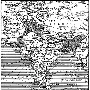
Map exhibiting the present partition of the country dependent on Fort St

![]()
Wall Art and Photo Gifts from Fine Art Finder
Map exhibiting the present partition of the country dependent on Fort St
3062959 Map exhibiting the present partition of the country dependent on Fort St. George into military divisions with several stations of troops, 1843 (pen, ink & w/c on paper) by English School, (19th century); National Army Museum, London; (add.info.: Pen, ink and watercolour map: Map Exhibiting the present partition of the Country dependent on Fort St. George into Military Divisions with several Stations of Troops. Agreeably to the General Distribution Return of the Coast Army For the Month of September 1843.
In addition to giving the distribution of the regiments of both the crown and the East India Company, this map also indicates the whereabouts of companies of veterans. ); eNational Army Museum; English, out of copyright
Media ID 23114758
© National Army Museum / Bridgeman Images
FEATURES IN THESE COLLECTIONS
> Arts
> Artists
> I
> Indian School Indian School
> Arts
> Still life artwork
> Watercolor paintings
> Fine art
> Asia
> India
> Related Images
> Europe
> United Kingdom
> England
> London
> Art
> Paintings
> Europe
> United Kingdom
> England
> London
> Museums
> National Army Museum
> Fine Art Finder
> Artists
> English School
> Fine Art Finder
> Artists
> Giuseppe Chiesa
> Fine Art Finder
> Maps (celestial & Terrestrial)
> Maps and Charts
> India
> Maps and Charts
> Related Images
EDITORS COMMENTS
The print showcases a captivating map titled "Map exhibiting the present partition of the country dependent on Fort St. George into military divisions with several stations of troops, 1843". Created by an English School in the 19th century, this pen, ink, and watercolor masterpiece is housed at the National Army Museum in London. This intricate map not only presents the division of territories under Fort St. George's influence but also provides valuable information about troop locations and distribution as per the General Distribution Return of the Coast Army for September 1843. It offers a comprehensive overview of both crown regiments and those belonging to the East India Company. What sets this map apart is its inclusion of companies of veterans' whereabouts alongside regular troops. This additional detail adds depth to our understanding of military presence during that time period. As we delve into this historical artifact, we are transported back to colonial India when British forces were strategically stationed across various regions. The meticulous craftsmanship evident in every stroke highlights both artistic skill and cartographic precision. Through this print from Fine Art Finder brought to us by Bridgeman Images, we can appreciate how maps serve not only as navigational tools but also as windows into past eras.
MADE IN THE USA
Safe Shipping with 30 Day Money Back Guarantee
FREE PERSONALISATION*
We are proud to offer a range of customisation features including Personalised Captions, Color Filters and Picture Zoom Tools
SECURE PAYMENTS
We happily accept a wide range of payment options so you can pay for the things you need in the way that is most convenient for you
* Options may vary by product and licensing agreement. Zoomed Pictures can be adjusted in the Cart.