Home > Europe > United Kingdom > England > London > Events > Trooping the Colour
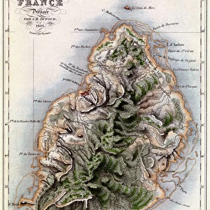
Island of Mauritius, 1804 (paper)
")
![]()
Wall Art and Photo Gifts from Fine Art Finder
Island of Mauritius, 1804 (paper)
7340499 Island of Mauritius, 1804 (paper) by Campbell, James (19th century); 53.5x41 cm; National Maritime Museum, London, UK; (add.info.: Creator: James Campbell
Scale: 1:500 000, in leagues and North at 263 degrees. The anchorages and rocks but no soundings are shown. The chart also shows the roads and fortifications on the island, the cruising station for frigates of observation, stations for the ships of war and troop transports and passages to the harbour at Grand Port.); © National Maritime Museum, Greenwich, London
Media ID 38410224
© © National Maritime Museum, Greenwich, London / Bridgeman Images
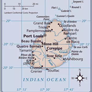
Islands Isles Mascarene Islands Mauritius
FEATURES IN THESE COLLECTIONS
> Africa
> Mauritius
> Related Images
> Animals
> Mammals
> Cercopithecidae
> Mauritius
> Europe
> United Kingdom
> England
> London
> Boroughs
> Greenwich
> Europe
> United Kingdom
> England
> London
> Events
> Trooping the Colour
> Europe
> United Kingdom
> England
> London
> Museums
> Greenwich Heritage Centre
> Europe
> United Kingdom
> England
> London
> Museums
> London Transport Museum
> Europe
> United Kingdom
> England
> London
> Museums
> National Maritime Museum
> Europe
> United Kingdom
> England
> London
> Towns
> Greenwich
> Europe
> United Kingdom
> Heritage Sites
> Maritime Greenwich
> Fine Art Finder
> Artists
> Greenvile Collins
> Fine Art Finder
> Artists
> James Campbell
EDITORS COMMENTS
This stunning vintage map print of the Island of Mauritius from 1804 captures the essence of a bygone era with its intricate details and vibrant colors. Created by James Campbell in the 19th century, this piece offers a unique glimpse into the cartography of that time.
The scale of 1:500,000 provides a comprehensive view of the island, showcasing anchorages, rocks, roads, fortifications, and even passages to the harbor at Grand Port. The chart also includes important information about cruising stations for frigates and ships of war, as well as troop transports.
Mauritius is depicted with precision and care on this paper print, highlighting its strategic importance in the Indian Ocean. The rich history and cultural significance of this African island are beautifully captured in this artwork.
As you gaze upon this historical map print hanging on your wall, you can't help but feel transported back in time to an era when exploration and discovery were paramount. Let yourself be immersed in the beauty and detail of this exquisite piece from the National Maritime Museum in London.
MADE IN THE USA
Safe Shipping with 30 Day Money Back Guarantee
FREE PERSONALISATION*
We are proud to offer a range of customisation features including Personalised Captions, Color Filters and Picture Zoom Tools
SECURE PAYMENTS
We happily accept a wide range of payment options so you can pay for the things you need in the way that is most convenient for you
* Options may vary by product and licensing agreement. Zoomed Pictures can be adjusted in the Cart.