Home > Arts > Artists > I > Indian School Indian School
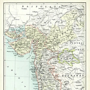
Map of Cutch and Bombay Presidency, India, 1898 (colour litho)
")
![]()
Wall Art and Photo Gifts from Fine Art Finder
Map of Cutch and Bombay Presidency, India, 1898 (colour litho)
XCF306009 Map of Cutch and Bombay Presidency, India, 1898 (colour litho) by English School, (19th century); Private Collection; English, out of copyright
Media ID 22660186
© Bridgeman Images
Arabian Sea British Empire Geographical Maharashtra Mapping Mumbai Kutch
FEATURES IN THESE COLLECTIONS
> Arts
> Artists
> I
> Indian School Indian School
> Asia
> India
> Related Images
> Asia
> Related Images
> Fine Art Finder
> Artists
> English School
> Fine Art Finder
> Artists
> Harold Copping
> Maps and Charts
> British Empire Maps
> Maps and Charts
> India
> Maps and Charts
> Related Images
EDITORS COMMENTS
This print showcases a beautifully detailed "Map of Cutch and Bombay Presidency, India" from 1898. Created by the English School in the 19th century, this colour lithograph provides a fascinating glimpse into the cartography and geography of the region during that time. The map encompasses not only Cutch and Bombay Presidency but also stretches across various parts of India, including Maharashtra and Mumbai (formerly known as Bombay). It highlights the vastness of the British Empire's influence in Asia, with its intricate depiction of Arabian Sea coastlines and neighboring territories. As we delve into this historical piece, we are transported back to an era when mapping was both an art form and a vital tool for understanding lands far beyond our reach. The attention to detail is evident in every stroke, showcasing rivers winding through lush landscapes, cities marked with precision, and mountain ranges majestically rising from their surroundings. This print serves as a reminder of how maps have played a crucial role in shaping our perception of the world throughout history. It invites us to explore not only physical boundaries but also cultural connections between different regions within India's diverse tapestry. With its rich colors and meticulous craftsmanship preserved over time, this image captivates viewers' imaginations while offering valuable insights into past civilizations. A true testament to human curiosity about our planet's wonders!
MADE IN THE USA
Safe Shipping with 30 Day Money Back Guarantee
FREE PERSONALISATION*
We are proud to offer a range of customisation features including Personalised Captions, Color Filters and Picture Zoom Tools
SECURE PAYMENTS
We happily accept a wide range of payment options so you can pay for the things you need in the way that is most convenient for you
* Options may vary by product and licensing agreement. Zoomed Pictures can be adjusted in the Cart.