Home > Animals > Insects > Hemiptera > Black Scale
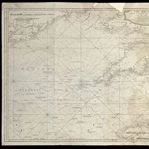
A new and accurate chart of the Baltic or East Sea showing the islands, rocks and shoals with their marks, light-houses, soundings and sailing channels, 1779 (print)
")
![]()
Wall Art and Photo Gifts from Fine Art Finder
A new and accurate chart of the Baltic or East Sea showing the islands, rocks and shoals with their marks, light-houses, soundings and sailing channels, 1779 (print)
7340659 A new and accurate chart of the Baltic or East Sea showing the islands, rocks and shoals with their marks, light-houses, soundings and sailing channels, 1779 (print) by Sayer, Robert (1724/5-94); 124.5x102.5 cm; National Maritime Museum, London, UK; (add.info.: Creator: Captain George Watson; Robert Sayer & John Bennett
Printed for Robert Sayer and J. N. Bennett, Fleet Street. Scale: circa 1:1,000,000 (latitude). Chart of the Baltic with five insets Insets: 1. Stockholm circa 1:350,000; 2. The Sound with the Road of Copenhagen and the Passage into the Baltic between Denmark and Sweden circa 1:250,000; 3. Rogerwick Bay circa 1:200,000; 4. A plan of the Isle of Gothland circa 1:350,000; 5. The Road of Riga with the Entrance of the River Dune circa 1:90,000.); © National Maritime Museum, Greenwich, London
Media ID 38372270
© © National Maritime Museum, Greenwich, London / Bridgeman Images
FEATURES IN THESE COLLECTIONS
> Animals
> Insects
> Hemiptera
> Black Scale
> Arts
> Artists
> W
> George White
> Arts
> Artists
> W
> John White
> Arts
> Artists
> W
> Robert White
> Europe
> Denmark
> Copenhagen
> Europe
> Denmark
> Related Images
> Fine Art Finder
> Artists
> Robert Sayer
EDITORS COMMENTS
This stunning print of "A new and accurate chart of the Baltic or East Sea" from 1779 is a true masterpiece of maritime cartography. Created by Captain George Watson and published by Robert Sayer and J. N. Bennett, this detailed map showcases the islands, rocks, shoals, light-houses, soundings, and sailing channels of the Baltic region.
Measuring at 124.5x102.5 cm, this print is not only visually impressive but also incredibly informative with five insets highlighting key areas such as Stockholm, The Sound with the Road of Copenhagen, Rogerwick Bay, Isle of Gothland, and the Road of Riga.
The intricate details on this map provide a glimpse into navigation in the 18th century and serve as a valuable historical document for understanding seafaring routes during that time period.
Displayed at the National Maritime Museum in London, UK, this print captures the essence of early cartography with its black-and-white aesthetic that adds to its timeless appeal.
Whether you are a history buff or simply appreciate fine artistry in mapmaking, this print is sure to captivate your imagination and transport you back to an era where exploration was at its peak.
MADE IN THE USA
Safe Shipping with 30 Day Money Back Guarantee
FREE PERSONALISATION*
We are proud to offer a range of customisation features including Personalised Captions, Color Filters and Picture Zoom Tools
SECURE PAYMENTS
We happily accept a wide range of payment options so you can pay for the things you need in the way that is most convenient for you
* Options may vary by product and licensing agreement. Zoomed Pictures can be adjusted in the Cart.