Home > Europe > United Kingdom > England > London > Sights > New River
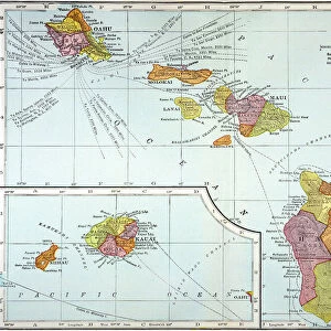
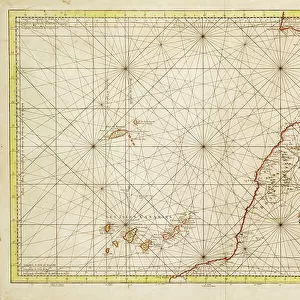
'Secretary of State for the Colonies &c. &c. &c. this chart of New Zealand from original surveys is respectfully dedicated by his very obedient servant, Thomas Mc.Donnell, Lieut. R.N.', 1834 (engraving)
")
![]()
Wall Art and Photo Gifts from Fine Art Finder
'Secretary of State for the Colonies &c. &c. &c. this chart of New Zealand from original surveys is respectfully dedicated by his very obedient servant, Thomas Mc.Donnell, Lieut. R.N.', 1834 (engraving)
7339385 'Secretary of State for the Colonies &c. &c. &c. this chart of New Zealand from original surveys is respectfully dedicated by his very obedient servant, Thomas Mc.Donnell, Lieut. R.N.', 1834 (engraving) by McDonnell, Thomas (19th century); 86x71 cm; National Maritime Museum, London, UK; (add.info.: Creator: Thomas McDonnell; James Wyld
Scale: ca. 1:2 000 000. The first inset is a plan of the entrance to Port Manoukao, with no scale, then there's an inset of a plan of the bar and part of the Hokianga River, scale: ca. 1:70 000, also an inset showing a plan of southern port, Stewart's Island, ca. 1:25 000, and the last inset shows a plan of Dusky Bay, ca. 1: 250 000.); © National Maritime Museum, Greenwich, London
Media ID 38176940
© © National Maritime Museum, Greenwich, London / Bridgeman Images
Dominion Of New Zealand New Zealand New Zealander New Zealanders Polynesia Polynesians Polynesisch
FEATURES IN THESE COLLECTIONS
> Animals
> Insects
> Hemiptera
> Black Scale
> Arts
> Artists
> B
> James Bayes
> Arts
> Artists
> P
> Polynesian Polynesian
> Europe
> United Kingdom
> England
> London
> Boroughs
> Greenwich
> Europe
> United Kingdom
> England
> London
> Museums
> Greenwich Heritage Centre
> Europe
> United Kingdom
> England
> London
> Museums
> National Maritime Museum
> Europe
> United Kingdom
> England
> London
> Sights
> New River
> Europe
> United Kingdom
> England
> London
> Towns
> Greenwich
> Europe
> United Kingdom
> Heritage Sites
> Maritime Greenwich
> Europe
> United Kingdom
> Maps
> Fine Art Finder
> Artists
> Jacques Nicolas Bellin
EDITORS COMMENTS
This stunning engraving from 1834, dedicated to the Secretary of State for the Colonies by Thomas McDonnell, provides a detailed chart of New Zealand based on original surveys. The intricate map showcases various insets including plans of Port Manoukao, Hokianga River, Stewart's Island, and Dusky Bay, offering a comprehensive view of the geography and topography of this beautiful land.
McDonnell's meticulous attention to detail is evident in the scale and precision with which he has depicted each region. From the entrance to ports to river systems and bays, every aspect of New Zealand's coastal areas is captured with accuracy and skill.
As we gaze upon this historical artwork, we are transported back in time to an era when exploration and cartography were at the forefront of discovery. The dedication shown by McDonnell in creating this chart reflects his commitment to serving his country and documenting new territories for future generations.
This engraving serves as a testament to both the artistry and scientific rigor involved in mapping uncharted lands. It stands as a reminder of our enduring fascination with exploration and our desire to understand the world around us.
MADE IN THE USA
Safe Shipping with 30 Day Money Back Guarantee
FREE PERSONALISATION*
We are proud to offer a range of customisation features including Personalised Captions, Color Filters and Picture Zoom Tools
SECURE PAYMENTS
We happily accept a wide range of payment options so you can pay for the things you need in the way that is most convenient for you
* Options may vary by product and licensing agreement. Zoomed Pictures can be adjusted in the Cart.