Home > Europe > United Kingdom > England > London > Museums > National Maritime Museum
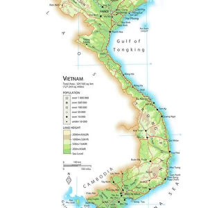
Carte d'une partie de la Mer de Chine dressee au Depot des Cartes et Plans de la Marine, sur les observations du Vice-Amiral Rosili, et publiee par ordre du Ministre. l'an 1798. 1798 (engraving)
")
![]()
Wall Art and Photo Gifts from Fine Art Finder
Carte d'une partie de la Mer de Chine dressee au Depot des Cartes et Plans de la Marine, sur les observations du Vice-Amiral Rosili, et publiee par ordre du Ministre. l'an 1798. 1798 (engraving)
7339386 Carte d'une partie de la Mer de Chine dressee au Depot des Cartes et Plans de la Marine, sur les observations du Vice-Amiral Rosili, et publiee par ordre du Ministre. l'an 1798. 1798 (engraving) by French School, (18th century); 99x66 cm; National Maritime Museum, London, UK; (add.info.: Creator: Depot Generale de la Marine; Rosili
Single sheet. Engr. Scale: [ca. 1:2 500 000]. Cartographic Note: Border graduated for lat & long, Paris meridian. Rhumb lines. Additional Places: Vietnam, Hainan.); © National Maritime Museum, Greenwich, London
Media ID 38408970
© © National Maritime Museum, Greenwich, London / Bridgeman Images
Indochina South East Asia Vietcong Vietnam Vietnam Vietnamese Vietnamese Asiae
FEATURES IN THESE COLLECTIONS
> Animals
> Insects
> Hemiptera
> Black Scale
> Asia
> Vietnam
> Related Images
> Europe
> France
> Paris
> Maps
> Europe
> United Kingdom
> England
> London
> Boroughs
> Greenwich
> Europe
> United Kingdom
> England
> London
> Museums
> Greenwich Heritage Centre
> Europe
> United Kingdom
> England
> London
> Museums
> National Maritime Museum
> Europe
> United Kingdom
> England
> London
> Towns
> Greenwich
> Europe
> United Kingdom
> Heritage Sites
> Maritime Greenwich
> Fine Art Finder
> Artists
> French School
EDITORS COMMENTS
This stunning engraving from 1798, titled Carte d'une partie de la Mer de Chine, offers a glimpse into the intricate world of cartography in the 18th century. Created by the French School and based on observations by Vice-Admiral Rosili, this map was meticulously crafted at the Depot des Cartes et Plans de la Marine.
Measuring 99x66 cm, this detailed map showcases parts of the South China Sea, including Vietnam and Hainan. The border is graduated for latitude and longitude with rhumb lines adding to its navigational utility. The Paris meridian serves as a reference point for orientation.
The historical significance of this piece is evident in its scale of approximately 1:2,500,000 - a testament to the precision and dedication of early cartographers. It provides valuable insights into maritime navigation during that era and sheds light on colonial interests in Asia.
Displayed at the National Maritime Museum in London, UK, this engraving captures not only geographical information but also cultural connections between Europe and Asia. Its black-and-white aesthetic adds a timeless quality to its depiction of an ever-changing seascape.
Overall, this print serves as a reminder of our enduring fascination with maps and exploration throughout history.
MADE IN THE USA
Safe Shipping with 30 Day Money Back Guarantee
FREE PERSONALISATION*
We are proud to offer a range of customisation features including Personalised Captions, Color Filters and Picture Zoom Tools
SECURE PAYMENTS
We happily accept a wide range of payment options so you can pay for the things you need in the way that is most convenient for you
* Options may vary by product and licensing agreement. Zoomed Pictures can be adjusted in the Cart.