Home > Animals > Insects > Spiders > European Garden
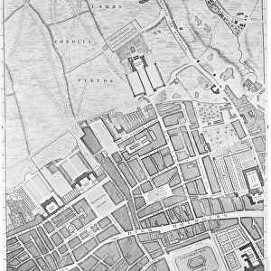
Map of Highgate, Kentish Town, Holloway, Tottenham and Newington, 1746 (coloured engraving)
")
![]()
Wall Art and Photo Gifts from Fine Art Finder
Map of Highgate, Kentish Town, Holloway, Tottenham and Newington, 1746 (coloured engraving)
7340507 Map of Highgate, Kentish Town, Holloway, Tottenham and Newington, 1746 (coloured engraving) by Rocque, John (c.1704-d.1762); 51x67 cm; National Maritime Museum, London, UK; (add.info.: Creator: John Rocque
Sheet from An exact survey of the cities of London and Westminster, the Borough of Southwark, with the country near ten miles round'. John Rocque came to England as a child with his French Huguenot family. He was an estate surveyor and garden designer before he began mapping towns.); © National Maritime Museum, Greenwich, London
Media ID 38515922
© © National Maritime Museum, Greenwich, London / Bridgeman Images
FEATURES IN THESE COLLECTIONS
> Animals
> Insects
> Spiders
> European Garden
> Arts
> Artists
> R
> John Rocque
> Europe
> Republic of Ireland
> Maps
> Europe
> United Kingdom
> England
> London
> Boroughs
> City of Westminster
> Europe
> United Kingdom
> England
> London
> Boroughs
> Greenwich
> Europe
> United Kingdom
> England
> London
> Boroughs
> Related Images
> Europe
> United Kingdom
> England
> London
> Boroughs
> Southwark
> Europe
> United Kingdom
> England
> London
> Museums
> British Museum
> Europe
> United Kingdom
> England
> London
> Museums
> Garden Museum
> Fine Art Finder
> Artists
> James Reynolds
> Fine Art Finder
> Artists
> John Rocque
EDITORS COMMENTS
This beautifully detailed coloured engraving from 1746 depicts a map of Highgate, Kentish Town, Holloway, Tottenham and Newington, providing a fascinating glimpse into the layout of these areas in the 18th century. Created by John Rocque as part of his larger work 'An exact survey of the cities of London and Westminster', this piece showcases his skill as both an estate surveyor and garden designer turned cartographer.
Rocque's meticulous attention to detail is evident in every street and building depicted on the map, offering a snapshot of life in these bustling towns during this period. The vibrant colours used bring the map to life, highlighting key landmarks and features that would have been important to residents at the time.
As we study this historical document, we are transported back in time to an era when these areas were still developing and evolving. The intricate engravings capture not just geographical information but also provide insight into the social fabric and urban planning of these communities.
This print serves as a valuable reminder of our rich history and heritage, preserving for future generations a visual record of how these neighborhoods looked centuries ago. It is a testament to Rocque's talent as a cartographer and his dedication to documenting the world around him with precision and artistry.
MADE IN THE USA
Safe Shipping with 30 Day Money Back Guarantee
FREE PERSONALISATION*
We are proud to offer a range of customisation features including Personalised Captions, Color Filters and Picture Zoom Tools
SECURE PAYMENTS
We happily accept a wide range of payment options so you can pay for the things you need in the way that is most convenient for you
* Options may vary by product and licensing agreement. Zoomed Pictures can be adjusted in the Cart.