Home > Animals > Insects > Spiders > European Garden
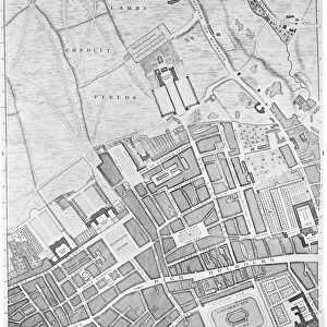
Map of Wimbledon and Tooting, 1746 (coloured engraving)
")
![]()
Wall Art and Photo Gifts from Fine Art Finder
Map of Wimbledon and Tooting, 1746 (coloured engraving)
7340512 Map of Wimbledon and Tooting, 1746 (coloured engraving) by Rocque, John (c.1704-d.1762); 51x67 cm; National Maritime Museum, London, UK; (add.info.: Creator: John Rocque
Sheet from An exact survey of the cities of London and Westminster, the Borough of Southwark, with the country near ten miles round'. John Rocque came to England as a child with his French Huguenot family. He was an estate surveyor and garden designer before he began mapping towns.); © National Maritime Museum, Greenwich, London
Media ID 38515928
© © National Maritime Museum, Greenwich, London / Bridgeman Images
FEATURES IN THESE COLLECTIONS
> Animals
> Insects
> Spiders
> European Garden
> Arts
> Artists
> R
> John Rocque
> Europe
> Republic of Ireland
> Maps
> Europe
> United Kingdom
> England
> London
> Boroughs
> City of Westminster
> Europe
> United Kingdom
> England
> London
> Boroughs
> Greenwich
> Europe
> United Kingdom
> England
> London
> Boroughs
> Related Images
> Europe
> United Kingdom
> England
> London
> Boroughs
> Southwark
> Europe
> United Kingdom
> England
> London
> Museums
> British Museum
> Europe
> United Kingdom
> England
> London
> Museums
> Garden Museum
> Fine Art Finder
> Artists
> James & Son Imray
> Fine Art Finder
> Artists
> John Rocque
EDITORS COMMENTS
This beautifully detailed coloured engraving from 1746 showcases a Map of Wimbledon and Tooting, created by the talented John Rocque. The intricate design captures the essence of these historic English towns, providing a glimpse into their layout and surroundings during the 18th century.
John Rocque's expertise as an estate surveyor and garden designer shines through in this map, demonstrating his keen eye for detail and precision. His work on 'An exact survey of the cities of London and Westminster' is evident in this piece, showcasing his dedication to accurately mapping out various locations.
As you study this print closely, you can appreciate the artistry involved in creating such a comprehensive depiction of Wimbledon and Tooting. The vibrant colours bring life to the streets, buildings, and landscapes depicted on the map, offering a unique perspective on these iconic English towns.
Whether you have a personal connection to Wimbledon or Tooting or simply appreciate historical cartography, this print is sure to captivate your imagination. It serves as a reminder of England's rich history and cultural heritage while highlighting John Rocque's remarkable talent as a mapmaker.
MADE IN THE USA
Safe Shipping with 30 Day Money Back Guarantee
FREE PERSONALISATION*
We are proud to offer a range of customisation features including Personalised Captions, Color Filters and Picture Zoom Tools
SECURE PAYMENTS
We happily accept a wide range of payment options so you can pay for the things you need in the way that is most convenient for you
* Options may vary by product and licensing agreement. Zoomed Pictures can be adjusted in the Cart.