Home > Europe > United Kingdom > England > London > Museums > National Maritime Museum
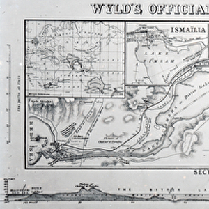
Black Sea, chart of the South-West Coast of the Krimea from Cape Aia to Alma Bay. By the officers of H.M.S.V. Spitfire., 1855 (lithograph)
")
![]()
Wall Art and Photo Gifts from Fine Art Finder
Black Sea, chart of the South-West Coast of the Krimea from Cape Aia to Alma Bay. By the officers of H.M.S.V. Spitfire., 1855 (lithograph)
7339542 Black Sea, chart of the South-West Coast of the Krimea from Cape Aia to Alma Bay. By the officers of H.M.S.V. Spitfire., 1855 (lithograph) by Malby (fl.1869); 125x79 cm; National Maritime Museum, London, UK; (add.info.: Creator: Malby & Sons; Hydrographic Office; Vice-Admiral Thomas A.B. Spratt
Scale: ca.1:42 500, in nautical miles. It shows soundings, seabed contours, has variation and general current direction shown. It also shows Crimea, French lines and fortifications, two long views, one coloured and one uncoloured with a smaller view.); © National Maritime Museum, Greenwich, London
Media ID 38339696
© © National Maritime Museum, Greenwich, London / Bridgeman Images
Black Sea Coast Line Lithos Litography
FEATURES IN THESE COLLECTIONS
> Animals
> Insects
> Hemiptera
> Black Scale
> Europe
> United Kingdom
> England
> London
> Boroughs
> Greenwich
> Europe
> United Kingdom
> England
> London
> Museums
> Greenwich Heritage Centre
> Europe
> United Kingdom
> England
> London
> Museums
> National Maritime Museum
> Europe
> United Kingdom
> England
> London
> Towns
> Greenwich
> Europe
> United Kingdom
> Heritage Sites
> Maritime Greenwich
> Europe
> United Kingdom
> Maps
> Fine Art Finder
> Artists
> James the Younger Wyld
> Fine Art Finder
> Artists
> Malby
> Maps and Charts
> Early Maps
EDITORS COMMENTS
This stunning lithograph print from 1855 captures the intricate details of the Black Sea, specifically focusing on the South-West Coast of Crimea from Cape Aia to Alma Bay. Created by the officers of H.M.S.V. Spitfire, this chart is a testament to their meticulous work and dedication to accurately mapping out this region.
The scale of approximately 1:42,500 in nautical miles allows for a comprehensive view of soundings, seabed contours, variation, and general current direction. Additionally, it showcases Crimea itself along with French lines and fortifications present at that time.
What makes this piece truly special are the two long views included - one colored and one uncolored - providing different perspectives on the landscape. The attention to detail in this lithograph is evident in every stroke and line drawn by Malby & Sons.
As you gaze upon this historical artifact now housed at the National Maritime Museum in London, you can't help but appreciate the artistry and precision that went into creating such a detailed map of a significant maritime location. It serves as both a valuable navigational tool for sailors of the past and a beautiful piece of artwork for admirers today.
MADE IN THE USA
Safe Shipping with 30 Day Money Back Guarantee
FREE PERSONALISATION*
We are proud to offer a range of customisation features including Personalised Captions, Color Filters and Picture Zoom Tools
SECURE PAYMENTS
We happily accept a wide range of payment options so you can pay for the things you need in the way that is most convenient for you
* Options may vary by product and licensing agreement. Zoomed Pictures can be adjusted in the Cart.