Home > Europe > Germany > Maps
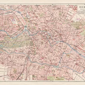
Map of Berlin, printed by C. L. Keller, Berlin, 1890 (colour litho)
")
![]()
Wall Art and Photo Gifts from Fine Art Finder
Map of Berlin, printed by C. L. Keller, Berlin, 1890 (colour litho)
AGD355564 Map of Berlin, printed by C.L. Keller, Berlin, 1890 (colour litho) by Straube, Jul. (fl.1890); 51.1x65.2 cm; Private Collection; (add.info.: Illustrierter Plan von Berlin; ); German, out of copyright
Media ID 23252780
© Bridgeman Images
FEATURES IN THESE COLLECTIONS
> Europe
> Germany
> Related Images
> Fine Art Finder
> Maps (celestial & Terrestrial)
> Maps and Charts
> Related Images
EDITORS COMMENTS
This print showcases a beautifully detailed "Map of Berlin" printed by C. L. Keller in 1890. The vibrant colors and intricate lithography bring to life the rich history and topography of Germany's capital city during that era. Measuring at 51.1x65.2 cm, this map is a true testament to the artistry and craftsmanship of its creator, Jul. Straube. Every street, building, and landmark is meticulously illustrated, providing an invaluable glimpse into Berlin's past. The "Illustrierter Plan von Berlin" not only serves as a cartographic masterpiece but also offers a fascinating insight into the development of urban planning during the late 19th century. It allows us to trace the evolution of this iconic cityscape and witness how it has transformed over time. As we explore this vintage gem from a private collection, we are reminded of the importance of preserving historical artifacts like maps for future generations to appreciate and learn from. This particular piece holds immense value for historians, researchers, or anyone with an interest in German history or cartography. With its stunning visual appeal and wealth of information about Berlin's topographical layout, this map print by C. L. Keller truly stands as both an artistic marvel and a valuable historical document capturing the essence of one of Europe's most influential cities.
MADE IN THE USA
Safe Shipping with 30 Day Money Back Guarantee
FREE PERSONALISATION*
We are proud to offer a range of customisation features including Personalised Captions, Color Filters and Picture Zoom Tools
SECURE PAYMENTS
We happily accept a wide range of payment options so you can pay for the things you need in the way that is most convenient for you
* Options may vary by product and licensing agreement. Zoomed Pictures can be adjusted in the Cart.