Home > Europe > United Kingdom > England > London > Sport > Sailing
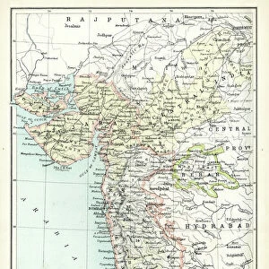
Coast of Western India from Bombay to Karachi compiled chiefly from the surveys made by order of the honorable East India Company, 1867 (print)
")
![]()
Wall Art and Photo Gifts from Fine Art Finder
Coast of Western India from Bombay to Karachi compiled chiefly from the surveys made by order of the honorable East India Company, 1867 (print)
7340648 Coast of Western India from Bombay to Karachi compiled chiefly from the surveys made by order of the honorable East India Company, 1867 (print) by Imray, James & Son (19th century); 130.5x103.5 cm; National Maritime Museum, London, UK; (add.info.: Creator: James Imray & Son
Scale: circa 1:750, 000. Blue-backed chart. Two joined sheets. Sailing directions for Karachi Harbour (printed in red) has been pasted-on below the Karachi inset. Two insets.
Insets: 1. Bombay Harbour circa 1:125, 000; 2. Karachi circa 1:40, 000.); © National Maritime Museum, Greenwich, London
Media ID 38372262
© © National Maritime Museum, Greenwich, London / Bridgeman Images
Bombay City Of Bombay Coast Line Mumbai Asiae
FEATURES IN THESE COLLECTIONS
> Animals
> Insects
> Hemiptera
> Black Scale
> Asia
> India
> Related Images
> Europe
> United Kingdom
> England
> London
> Boroughs
> Greenwich
> Europe
> United Kingdom
> England
> London
> Museums
> Greenwich Heritage Centre
> Europe
> United Kingdom
> England
> London
> Museums
> National Maritime Museum
> Europe
> United Kingdom
> England
> London
> Sport
> Sailing
> Europe
> United Kingdom
> England
> London
> Towns
> Greenwich
> Europe
> United Kingdom
> Heritage Sites
> Maritime Greenwich
> Fine Art Finder
> Artists
> James & Son Imray
> Fine Art Finder
> Artists
> Johannes II Van Keulen
EDITORS COMMENTS
This stunning print captures the Coast of Western India from Bombay to Karachi, compiled chiefly from surveys made by order of the honorable East India Company in 1867. Created by James Imray & Son, this intricate blue-backed chart showcases the detailed coastline with a scale of approximately 1:750,000.
The print features two joined sheets and includes insets of Bombay Harbour (circa 1:125,000) and Karachi (circa 1:40,000). Sailing directions for Karachi Harbour are printed in red below the Karachi inset, adding an extra layer of information to this historical map.
The meticulous cartography displayed in this print provides a glimpse into the early nineteenth century maritime navigation along the Indian coast. The imagery highlights key coastal landmarks and shorelines that were vital for sailors and traders during that time period.
From bustling Mumbai (formerly known as Bombay) to vibrant Karachi, this print offers a unique perspective on the rich history and geography of these important port cities. It serves as a valuable historical document that sheds light on the intricate mapping techniques used by explorers and navigators in the late nineteenth century.
MADE IN THE USA
Safe Shipping with 30 Day Money Back Guarantee
FREE PERSONALISATION*
We are proud to offer a range of customisation features including Personalised Captions, Color Filters and Picture Zoom Tools
SECURE PAYMENTS
We happily accept a wide range of payment options so you can pay for the things you need in the way that is most convenient for you
* Options may vary by product and licensing agreement. Zoomed Pictures can be adjusted in the Cart.