Home > Europe > United Kingdom > England > London > Museums > National Maritime Museum
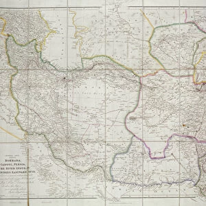
Chart of the Arctic regions from the Admiralty surveys, third edition, c.1854 (engraving)
")
![]()
Wall Art and Photo Gifts from Fine Art Finder
Chart of the Arctic regions from the Admiralty surveys, third edition, c.1854 (engraving)
7295402 Chart of the Arctic regions from the Admiralty surveys, third edition, c.1854 (engraving) by Wyld, James the Younger (1812-87); 37.5x40 cm; National Maritime Museum, London, UK; (add.info.: Creator: James Wyld
Scale: ca. 1:18 000 000 (latitude). The tracks of expeditions are colour coded and listed in the key. The search for Franklin continued until 1859.
Dedicated to Lady Franklin.); © National Maritime Museum, Greenwich, London
Media ID 38431296
© © National Maritime Museum, Greenwich, London / Bridgeman Images
Arctic Arctic Circle Excursion Explore North Pole Geographer
FEATURES IN THESE COLLECTIONS
> Europe
> United Kingdom
> England
> London
> Boroughs
> Greenwich
> Europe
> United Kingdom
> England
> London
> Museums
> Greenwich Heritage Centre
> Europe
> United Kingdom
> England
> London
> Museums
> National Maritime Museum
> Europe
> United Kingdom
> England
> London
> Towns
> Greenwich
> Europe
> United Kingdom
> Heritage Sites
> Maritime Greenwich
> Europe
> United Kingdom
> Maps
> Fine Art Finder
> Artists
> James the Younger Wyld
> Fine Art Finder
> Artists
> John Arrowsmith
> Maps and Charts
> Early Maps
EDITORS COMMENTS
This engraving, titled "Chart of the Arctic regions from the Admiralty surveys, third edition, c.1854," offers a glimpse into the exploration and discovery of the icy northern landscapes during the 19th century. Created by James Wyld the Younger, this detailed map showcases the tracks of various expeditions in vibrant colors, each carefully documented in a key for reference.
The search for Sir John Franklin and his ill-fated expedition is prominently featured on this chart, highlighting the relentless efforts to uncover the mystery surrounding their disappearance. Dedicated to Lady Franklin, this map serves as a testament to her unwavering determination to find her lost husband and his crew.
As you study this historical piece of cartography, you can't help but be drawn into the vastness and harsh beauty of the Arctic region. The intricate details and precise measurements reflect both scientific accuracy and artistic skill, making it a valuable resource for understanding early exploration efforts in these remote territories.
Whether you're an enthusiast of geography or simply appreciate fine craftsmanship, this engraving is sure to spark your curiosity about one of history's most challenging and intriguing frontiers - the Arctic Circle.
MADE IN THE USA
Safe Shipping with 30 Day Money Back Guarantee
FREE PERSONALISATION*
We are proud to offer a range of customisation features including Personalised Captions, Color Filters and Picture Zoom Tools
SECURE PAYMENTS
We happily accept a wide range of payment options so you can pay for the things you need in the way that is most convenient for you
* Options may vary by product and licensing agreement. Zoomed Pictures can be adjusted in the Cart.