Home > Europe > Iceland > Related Images
Mediterranean, Black Sea and the North East Atlantic, 1548 (vellum)
")
![]()
Wall Art and Photo Gifts from Fine Art Finder
Mediterranean, Black Sea and the North East Atlantic, 1548 (vellum)
7340478 Mediterranean, Black Sea and the North East Atlantic, 1548 (vellum) by Maggiolo, Jacopo Vesconte (1475-1549/61); 79x118 cm; National Maritime Museum, London, UK; (add.info.: Creator: Vesconte Maggiolo
Scale: 1:6.500 000. Additional Places shown are Norway, Iceland and Cape Verde. This portulan chart is exuberantly decorated with compass roses, towns, rulers, tents, mountains, animals and ships. Made in Genoa.); © National Maritime Museum, Greenwich, London
Media ID 38515912
© © National Maritime Museum, Greenwich, London / Bridgeman Images
Atlantic Atlantic Ocean Black Sea Cape Verde Iceland Icelander Icelandic Mediterranea Mediterranean Mediterranean Sea Mediterrean Mediterrean Sea Meditteranean Norway Norway Norwegian Norwegian Norwegians West Africa West African Western Africans C16h
FEATURES IN THESE COLLECTIONS
> Europe
> Iceland
> Related Images
> Europe
> Norway
> Related Images
> Europe
> United Kingdom
> Heritage Sites
> Maritime Greenwich
> Fine Art Finder
> Artists
> Jacopo Vesconte Maggiolo
> Fine Art Finder
> Artists
> John Burston
EDITORS COMMENTS
This stunning 16th-century portulan chart, depicting the Mediterranean, Black Sea, and North East Atlantic regions, is a true masterpiece of cartography. Created by the talented Vesconte Maggiolo in Genoa, Italy, this intricate map showcases not only geographical accuracy but also exquisite artistic detail.
Measuring an impressive 79x118 cm and drawn on vellum, this map is a visual feast for the eyes. From compass roses to towns, rulers to tents, mountains to animals and ships - every inch of this chart is adorned with elaborate decorations that bring it to life.
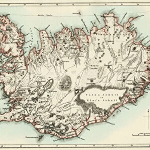
In addition to highlighting well-known regions such as France and Norway, this map also includes lesser-known areas like Iceland and Cape Verde. The scale of 1:6.500.000 ensures that even the smallest details are captured with precision.
As you study this historic piece of art, you can't help but marvel at the skill and dedication that went into its creation. It serves as a reminder of a time when maps were not just tools for navigation but works of art in their own right.
Now housed at the National Maritime Museum in London, UK, this print from Fine Art Finder allows us to appreciate the beauty and complexity of Maggiolo's work from centuries past.
MADE IN THE USA
Safe Shipping with 30 Day Money Back Guarantee
FREE PERSONALISATION*
We are proud to offer a range of customisation features including Personalised Captions, Color Filters and Picture Zoom Tools
SECURE PAYMENTS
We happily accept a wide range of payment options so you can pay for the things you need in the way that is most convenient for you
* Options may vary by product and licensing agreement. Zoomed Pictures can be adjusted in the Cart.