Home > Europe > United Kingdom > England > London > Museums > National Maritime Museum
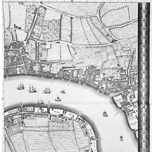
Chart of the North Sea and Dutch coast, 1661 (coloured engraving)
")
![]()
Wall Art and Photo Gifts from Fine Art Finder
Chart of the North Sea and Dutch coast, 1661 (coloured engraving)
7340609 Chart of the North Sea and Dutch coast, 1661 (coloured engraving) by British School, (17th century); 42x52 cm; National Maritime Museum, London, UK; (add.info.: Creator: Mount & Page
Bound in De Zee-Atlas ofte Water-wareld, published by Doncker in 1661.); © National Maritime Museum, Greenwich, London
Media ID 38515932
© © National Maritime Museum, Greenwich, London / Bridgeman Images
Coast Line North Sea Dutch Netherlands Hollander Hollanders Netherland Netherlands Holland Dutch The Netherland
FEATURES IN THESE COLLECTIONS
> Europe
> Netherlands
> Maps
> Europe
> Netherlands
> Posters
> Europe
> Netherlands
> Related Images
> Europe
> United Kingdom
> England
> London
> Boroughs
> Greenwich
> Europe
> United Kingdom
> England
> London
> Museums
> British Museum
> Europe
> United Kingdom
> England
> London
> Museums
> Greenwich Heritage Centre
> Europe
> United Kingdom
> England
> London
> Museums
> National Maritime Museum
> Europe
> United Kingdom
> England
> London
> Sights
> British Museum
> Europe
> United Kingdom
> England
> London
> Towns
> Greenwich
> Europe
> United Kingdom
> Heritage Sites
> Maritime Greenwich
> Fine Art Finder
> Artists
> British School
> Fine Art Finder
> Artists
> John Rocque
EDITORS COMMENTS
This stunning coloured engraving from 1661 showcases a detailed Chart of the North Sea and Dutch coast, providing a glimpse into maritime navigation during the 17th century. Measuring at 42x52 cm, this piece is part of the collection at the National Maritime Museum in London, UK.
Created by Mount & Page and bound in 'De Zee-Atlas ofte Water-wareld', published by Doncker in 1661, this map offers a historical perspective on cartography and coastal geography. The intricate details captured in this engraving highlight the skill and artistry of the unknown British School artist from the 17th century.
The vibrant colours used to bring this chart to life add an element of visual appeal to an otherwise technical representation. The coastlines, shorelines, and sea are depicted with precision, showcasing not only navigational accuracy but also artistic flair.
As you gaze upon this print, you can almost imagine sailors using similar maps to guide their ships through treacherous waters towards safe harbours along the Dutch coast. This piece serves as a reminder of our rich maritime history and the importance of accurate cartography in exploring new horizons.
MADE IN THE USA
Safe Shipping with 30 Day Money Back Guarantee
FREE PERSONALISATION*
We are proud to offer a range of customisation features including Personalised Captions, Color Filters and Picture Zoom Tools
SECURE PAYMENTS
We happily accept a wide range of payment options so you can pay for the things you need in the way that is most convenient for you
* Options may vary by product and licensing agreement. Zoomed Pictures can be adjusted in the Cart.