Home > Europe > United Kingdom > England > Herefordshire > Ledbury > Charles II
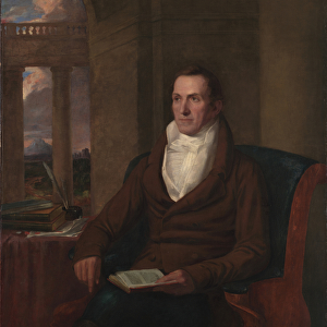
A new mappe of the sea coasts of England, France and Holland, wherein the English names, situation, point of the compass, and distance of the several ports, harbours, havens, creeks, sands. 1675 (coloured engraving)
")
![]()
Wall Art and Photo Gifts from Fine Art Finder
A new mappe of the sea coasts of England, France and Holland, wherein the English names, situation, point of the compass, and distance of the several ports, harbours, havens, creeks, sands. 1675 (coloured engraving)
7340046 A new mappe of the sea coasts of England, France and Holland, wherein the English names, situation, point of the compass, and distance of the several ports, harbours, havens, creeks, sands. 1675 (coloured engraving) by Seller, John (1632-97); 54x43 cm; National Maritime Museum, London, UK; (add.info.: Creator: John Seller
A chart from Atlas Maritimus, or the Sea Atlas; being a book of maritime charts. John Seller was Hydrographer to King Charles II. North at 349 degrees. Borders graduated for latitude. Bar scales in English, French and Dutch miles. Contains a dedication to James, Duke of York, in a cartouche decorated with his arms. Title and scale cartouches decorated with surveying putti.); © National Maritime Museum, Greenwich, London
Media ID 38515510
© © National Maritime Museum, Greenwich, London / Bridgeman Images
Coast Line Dutch Netherlands Hollander Hollanders Netherland Netherlands Holland Dutch The Netherland
FEATURES IN THESE COLLECTIONS
> Arts
> Artists
> C
> James Charles
> Arts
> Artists
> C
> King Charles
> Arts
> Artists
> H
> James Holland
> Arts
> Artists
> S
> John Seller
> Europe
> Netherlands
> Maps
> Europe
> Netherlands
> Posters
> Europe
> Netherlands
> Related Images
> Europe
> Republic of Ireland
> Maps
> Europe
> United Kingdom
> England
> Herefordshire
> Ledbury
> Charles II
> Fine Art Finder
> Artists
> John Seller
EDITORS COMMENTS
This beautifully detailed coloured engraving from 1675, titled 'A new mappe of the sea coasts of England, France and Holland', offers a fascinating glimpse into maritime cartography during the 17th century. Created by John Seller, who served as Hydrographer to King Charles II, this chart is part of his 'Atlas Maritimus', or the Sea Atlas.
The map provides English names, compass points, distances, and other essential information for ports, harbours, havens, creeks, and sands along the coastlines of England, France and Holland. The borders are graduated for latitude and there are bar scales in English, French and Dutch miles.
Intricate decorative elements adorn the cartouches throughout the map - including a dedication to James Duke of York with his arms displayed prominently. Surveying putti add a whimsical touch to the title and scale cartouches.
This historical print not only serves as a valuable navigational tool but also showcases the artistry involved in early modern cartography. It transports viewers back in time to an era when exploration and discovery were at their peak. A true masterpiece that captures both practicality and beauty in one stunning image.
MADE IN THE USA
Safe Shipping with 30 Day Money Back Guarantee
FREE PERSONALISATION*
We are proud to offer a range of customisation features including Personalised Captions, Color Filters and Picture Zoom Tools
SECURE PAYMENTS
We happily accept a wide range of payment options so you can pay for the things you need in the way that is most convenient for you
* Options may vary by product and licensing agreement. Zoomed Pictures can be adjusted in the Cart.