Home > Europe > United Kingdom > England > Merseyside > Liverpool
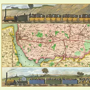
Map of the Liverpool and Manchester Railway showing the line as surveyed by George Stephenson (colour litho)
")
![]()
Wall Art and Photo Gifts from Fine Art Finder
Map of the Liverpool and Manchester Railway showing the line as surveyed by George Stephenson (colour litho)
3697573 Map of the Liverpool and Manchester Railway showing the line as surveyed by George Stephenson (colour litho) by English School, (19th century); Private Collection; (add.info.: Map of the Liverpool and Manchester Railway showing the line as surveyed by George Stephenson.); SSPL/UIG
Media ID 23647568
© SSPL/UIG / Bridgeman Images
Liverpool Manchester Merseyside Rail Transport Rail Travel Railway Transport
FEATURES IN THESE COLLECTIONS
> Europe
> United Kingdom
> England
> Liverpool
> Europe
> United Kingdom
> England
> Manchester
> Manchester
> Europe
> United Kingdom
> England
> Maps
> Europe
> United Kingdom
> England
> Merseyside
> Liverpool
> Europe
> United Kingdom
> England
> Merseyside
> Related Images
> Europe
> United Kingdom
> England
> Railways
> Europe
> United Kingdom
> Maps
> Europe
> United Kingdom
> Related Images
> Fine Art Finder
> Artists
> English School
> Fine Art Finder
> Artists
> John Urpeth Rastrick
> Maps and Charts
> Related Images
> Popular Themes
> Railway Posters
EDITORS COMMENTS
This vibrant and detailed print captures the historical significance of the Liverpool and Manchester Railway, as surveyed by George Stephenson. The map showcases the intricate network of rail lines that revolutionized transportation in 19th century England. The bold colors used in this lithograph bring to life the extensive railway system that connected two major cities, Liverpool and Manchester. It serves as a testament to the ingenuity and vision of George Stephenson, who played a pivotal role in designing this groundbreaking railway. As you gaze upon this image, you can almost envision the steam-powered locomotives chugging along these tracks, carrying passengers and goods between these bustling urban centers. The map not only provides a geographical representation but also offers insight into an era when rail travel was transforming society. Transportation enthusiasts will appreciate how this print encapsulates an important chapter in British history. It symbolizes progress, innovation, and connectivity during a time when railways were reshaping economies and communities across Europe. Whether you are fascinated by trains or simply intrigued by historical artifacts, this print is sure to captivate your imagination. Its rich colors and intricate details make it an ideal addition to any collection celebrating Britain's industrial heritage or transportation advancements throughout history.
MADE IN THE USA
Safe Shipping with 30 Day Money Back Guarantee
FREE PERSONALISATION*
We are proud to offer a range of customisation features including Personalised Captions, Color Filters and Picture Zoom Tools
SECURE PAYMENTS
We happily accept a wide range of payment options so you can pay for the things you need in the way that is most convenient for you
* Options may vary by product and licensing agreement. Zoomed Pictures can be adjusted in the Cart.