Home > Arts > Artists > H > Joris Hoefnagel
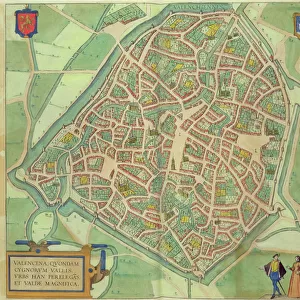
Map of Calais, from Civitates Orbis Terrarum by Georg Braun (1541-1622

![]()
Wall Art and Photo Gifts from Fine Art Finder
Map of Calais, from Civitates Orbis Terrarum by Georg Braun (1541-1622
STC121032 Map of Calais, from Civitates Orbis Terrarum by Georg Braun (1541-1622) and Frans Hogenberg (1535-90), 1597 (colour engraving) by Hoefnagel, Joris (1542-1600) (after); Private Collection; The Stapleton Collection; Flemish, out of copyright
Media ID 22346446
© The Stapleton Collection / Bridgeman Images
Channel Cities Of The World Halbard
FEATURES IN THESE COLLECTIONS
> Arts
> Artists
> H
> Joris Hoefnagel
> Fine Art Finder
> Artists
> Joris (after) Hoefnagel
> Fine Art Finder
> Maps (celestial & Terrestrial)
> Maps and Charts
> Related Images
> Maps and Charts
> World
EDITORS COMMENTS
This print showcases the intricate "Map of Calais" from the renowned Civitates Orbis Terrarum collection by Georg Braun and Frans Hogenberg. Created in 1597, this exquisite colour engraving is a testament to the exceptional craftsmanship of Joris Hoefnagel. The map transports us back in time, offering a glimpse into the historical significance of Calais. The city's strategic location as a port on the English Channel is highlighted, emphasizing its importance as a hub for trade and maritime activities. The meticulously detailed fortifications surrounding Calais serve as a reminder of its defensive capabilities during an era marked by constant territorial disputes. As we explore this remarkable artwork, we are drawn to the bustling cityscape depicted within its walls. Every street and building is intricately etched, showcasing the architectural beauty that once graced Calais' streets. The presence of ships sailing through the channel adds an element of liveliness to this snapshot frozen in time. This particular print captures not only geographical accuracy but also evokes emotions associated with exploration and discovery. It serves as a visual portal into history, inviting us to immerse ourselves in an era long gone. Displayed here courtesy of Bridgeman Images from their private collection, this stunning piece exemplifies why fine art enthusiasts continue to be captivated by maps like these – they offer both aesthetic pleasure and invaluable insights into our past.
MADE IN THE USA
Safe Shipping with 30 Day Money Back Guarantee
FREE PERSONALISATION*
We are proud to offer a range of customisation features including Personalised Captions, Color Filters and Picture Zoom Tools
SECURE PAYMENTS
We happily accept a wide range of payment options so you can pay for the things you need in the way that is most convenient for you
* Options may vary by product and licensing agreement. Zoomed Pictures can be adjusted in the Cart.