Home > Europe > United Kingdom > England > London > Sights > New River
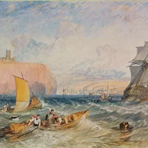
The River St. John, 1780 (engraving)
")
![]()
Wall Art and Photo Gifts from Fine Art Finder
The River St. John, 1780 (engraving)
7340407 The River St. John, 1780 (engraving) by DesBarres, Joseph Frederick Wallet (1721-1824); 54.5x78.5 cm; National Maritime Museum, London, UK; (add.info.: Creator: J. F. W. Des Barres
Scale: ca. 1:30 000 (bar). Cartographic Note: North at 14 degrees. Variation shown. Bar scales in statute and nautical miles. Additional Places: New Brunswick. Contents Note: The title includes sailing directions and tidal information, A view of the entrance to the River St. John.); © National Maritime Museum, Greenwich, London
Media ID 38371938
© © National Maritime Museum, Greenwich, London / Bridgeman Images
FEATURES IN THESE COLLECTIONS
> Animals
> Insects
> Hemiptera
> Black Scale
> Arts
> Artists
> W
> John White
> Europe
> United Kingdom
> England
> London
> Boroughs
> Greenwich
> Europe
> United Kingdom
> England
> London
> Museums
> Greenwich Heritage Centre
> Europe
> United Kingdom
> England
> London
> Museums
> National Maritime Museum
> Europe
> United Kingdom
> England
> London
> Politics
> Frederick North
> Europe
> United Kingdom
> England
> London
> Sights
> New River
> Europe
> United Kingdom
> England
> London
> Sport
> Sailing
> Europe
> United Kingdom
> England
> London
> Towns
> Greenwich
> Europe
> United Kingdom
> Heritage Sites
> Maritime Greenwich
> Fine Art Finder
> Artists
> Joseph Frederick Wallet DesBarres
EDITORS COMMENTS
This stunning engraving of The River St. John from 1780 by Joseph Frederick Wallet DesBarres captures the beauty and intricacy of cartography in the 18th century. The detailed map, measuring 54.5x78.5 cm, provides a glimpse into the past with its depiction of New Brunswick and sailing directions for navigating the river.
DesBarres' skill as an engraver is evident in the precision and accuracy of this piece, showcasing his dedication to capturing every detail of the landscape. The inclusion of tidal information and a view of the entrance to The River St. John adds depth to this historical map, offering valuable insights into navigation during that time period.
As we study this engraving, we are transported back to a time when maps were essential tools for exploration and trade in North America. The scale of approximately 1:30,000 allows us to appreciate the vastness of the river and surrounding areas, while also highlighting DesBarres' attention to geographic accuracy.
This print from the National Maritime Museum in London serves as a reminder of our connection to history through cartography, providing a window into how early explorers navigated unknown territories with skill and precision. It is truly a masterpiece that continues to captivate viewers centuries later.
MADE IN THE USA
Safe Shipping with 30 Day Money Back Guarantee
FREE PERSONALISATION*
We are proud to offer a range of customisation features including Personalised Captions, Color Filters and Picture Zoom Tools
SECURE PAYMENTS
We happily accept a wide range of payment options so you can pay for the things you need in the way that is most convenient for you
* Options may vary by product and licensing agreement. Zoomed Pictures can be adjusted in the Cart.