Home > Europe > United Kingdom > England > London > Politics > George Canning
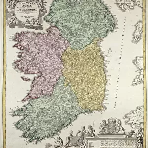
Donegal and Sligo Bays, Ireland, c.1600 (linen, paper)
")
![]()
Wall Art and Photo Gifts from Fine Art Finder
Donegal and Sligo Bays, Ireland, c.1600 (linen, paper)
7339810 Donegal and Sligo Bays, Ireland, c.1600 (linen, paper) by Boazio, Baptista (fl.1588-1606); 44x58 cm; National Maritime Museum, London, UK; (add.info.: Creator: Baptista Boazio
A true description of the Norwest partes of Irelande wherin is showed the most parte of O'Donnells contre, part of Tirones, part of McGuyres, part of Orowercks: all of the Co. of Slego, part of McWillms and parte of the Co. of Roscomon truly collected & observed by Captain John Baxter. Finished by Baptista Boazio.
Scale: [ca. 1:250 000 (meas)]. Cartographic Note: North at 270 degrees. Scale in Irish miles. Contents Note: Houses, churches and forts depicted. Roads marked, relief indicated, Depiction of 3 Spanishe shippes cast away in ao 88 (Armada wrecks at Streedagh), Text notes relating local legends: sighting of 2 water horses of a huge bigness'; a holy man who can, by turning stones, cause the death of people who anger him; a bog where scenes of battles, castles and cattle can appear. From volume eight, Maps of Ireland, of the Dartmouth collection of maps and plans, compiled for or by George Legge, Master General of the Ordnance.); © National Maritime Museum, Greenwich, London
Media ID 38372732
© © National Maritime Museum, Greenwich, London / Bridgeman Images
FEATURES IN THESE COLLECTIONS
> Animals
> Farm
> Cattle
> Related Images
> Animals
> Mammals
> Bovidae
> Cattle
> Animals
> Mammals
> Pitheciidae
> Baptista
> Arts
> Artists
> B
> Baptista Boazio
> Arts
> Artists
> B
> George Baxter
> Europe
> Republic of Ireland
> Maps
> Europe
> United Kingdom
> England
> London
> Boroughs
> Greenwich
> Europe
> United Kingdom
> England
> London
> Museums
> Greenwich Heritage Centre
> Europe
> United Kingdom
> England
> London
> Museums
> National Maritime Museum
> Europe
> United Kingdom
> England
> London
> Politics
> George Canning
> Fine Art Finder
> Artists
> Baptista Boazio
> Fine Art Finder
> Artists
> Luis de Surville
EDITORS COMMENTS
This stunning print captures the beauty and history of Donegal and Sligo Bays in Ireland, dating back to around 1600. The intricate details of this map, created by Baptista Boazio, provide a glimpse into the past with depictions of O'Donnells country, Tirones, McGuyres, Orowercks, Slego County, McWillms, and Roscomon County.
Captain John Baxter's observations are brought to life through Boazio's skilled hand as he finished this masterpiece. The scale is approximately 1:250 000 Irish miles with north at 270 degrees. Houses, churches, forts, and roads are marked on the map while relief is indicated for a more comprehensive view.
One notable feature depicted on this map is the Armada wrecks at Streedagh where three Spanish ships were cast away in ao 88. Local legends are also included in the text notes such as sightings of water horses and stories of a holy man who could cause harm by turning stones.
This print from the National Maritime Museum in London truly transports viewers back in time to explore the rich history and natural beauty of Donegal and Sligo Bays in Ireland. It serves as a reminder of our connection to the past and how it has shaped our present landscape.
MADE IN THE USA
Safe Shipping with 30 Day Money Back Guarantee
FREE PERSONALISATION*
We are proud to offer a range of customisation features including Personalised Captions, Color Filters and Picture Zoom Tools
SECURE PAYMENTS
We happily accept a wide range of payment options so you can pay for the things you need in the way that is most convenient for you
* Options may vary by product and licensing agreement. Zoomed Pictures can be adjusted in the Cart.