Home > Animals > Insects > Hemiptera > Black Scale
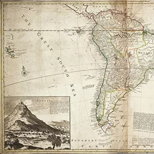
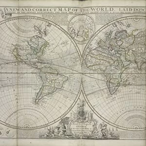
A new and correct map of the world, laid down according to the newest discoveries, and from the most exact observations, by Herman Moll, Geographer, 1709 (engraving, paper)
")
![]()
Wall Art and Photo Gifts from Fine Art Finder
A new and correct map of the world, laid down according to the newest discoveries, and from the most exact observations, by Herman Moll, Geographer, 1709 (engraving, paper)
7339544 A new and correct map of the world, laid down according to the newest discoveries, and from the most exact observations, by Herman Moll, Geographer, 1709 (engraving, paper) by Moll, Hermann (fl.1678-1732); 68x107 cm; National Maritime Museum, London, UK; (add.info.: Creator: Herman Moll; Midwinter and Bowles
Scale: circa 1:75,000,000. A double hemisphere projection with the prime meridian through Ferro and a north polar inset. The trade winds are indicated and Dampier's track around the world is shown. Diagrams illustrate the Ptolemean and Copernican solar systems and the sun, moon and planets according to Kircher and Cassini. The cartouche of the dedication to Prince George of Denmark is decorated with mermen, flags and ships. There are text notes on the inaccuracies of Sanson and Dutch mapping.); © National Maritime Museum, Greenwich, London
Media ID 38339698
© © National Maritime Museum, Greenwich, London / Bridgeman Images
FEATURES IN THESE COLLECTIONS
> Animals
> Insects
> Hemiptera
> Black Scale
> Animals
> Insects
> Hemiptera
> Hemispherical Scale
> Arts
> Artists
> M
> Herman Moll
> Arts
> Artists
> P
> George Prince
> Arts
> Artists
> W
> George White
> Europe
> Denmark
> Related Images
> Europe
> United Kingdom
> England
> London
> Boroughs
> Greenwich
> Europe
> United Kingdom
> England
> London
> Museums
> Greenwich Heritage Centre
> Fine Art Finder
> Artists
> Hermann Moll
> Fine Art Finder
> Artists
> Malby
EDITORS COMMENTS
This stunning engraving by Herman Moll, titled "A new and correct map of the world," offers a fascinating glimpse into the state of geographical knowledge in 1709. Moll, a renowned geographer of his time, meticulously laid down the map according to the newest discoveries and most exact observations available.
The double hemisphere projection with the prime meridian through Ferro provides a comprehensive view of the world as it was understood over three centuries ago. The inclusion of trade winds and Dampier's track around the world adds depth to this intricate piece.
Noteworthy are the diagrams illustrating both Ptolemaic and Copernican solar systems, as well as depictions of the sun, moon, and planets according to Kircher and Cassini. These details offer insight into contemporary understandings of astronomy.
The dedication cartouche adorned with mermen, flags, and ships pays homage to Prince George of Denmark while also serving as a decorative element within this historical artifact. Text notes on inaccuracies found in Sanson's maps further highlight Moll's commitment to accuracy in his work.
Overall, this print from the National Maritime Museum in London is not just a map but a window into early modern cartography and scientific thought. It stands as a testament to human curiosity and exploration during an era marked by significant advancements in understanding our place in the world.
MADE IN THE USA
Safe Shipping with 30 Day Money Back Guarantee
FREE PERSONALISATION*
We are proud to offer a range of customisation features including Personalised Captions, Color Filters and Picture Zoom Tools
SECURE PAYMENTS
We happily accept a wide range of payment options so you can pay for the things you need in the way that is most convenient for you
* Options may vary by product and licensing agreement. Zoomed Pictures can be adjusted in the Cart.