Home > Europe > United Kingdom > Heritage Sites > Maritime Greenwich
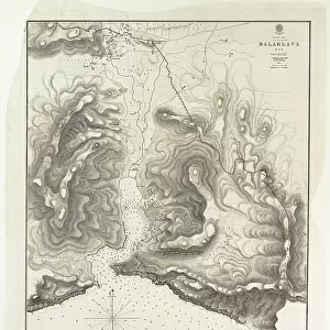
Sketch of the routes from Kustenjeh to Chernavoda and Rassova with the Karasu Lakes by Captain T. Spratt R.N. C.B. 24 July 1854, 1856 (lithograph)
")
![]()
Wall Art and Photo Gifts from Fine Art Finder
Sketch of the routes from Kustenjeh to Chernavoda and Rassova with the Karasu Lakes by Captain T. Spratt R.N. C.B. 24 July 1854, 1856 (lithograph)
7339550 Sketch of the routes from Kustenjeh to Chernavoda and Rassova with the Karasu Lakes by Captain T. Spratt R.N. C.B. 24 July 1854, 1856 (lithograph) by Spratt, Thomas (fl.1854); 102x50 cm; National Maritime Museum, London, UK; (add.info.: Creator: Vice-Admiral Thomas A. B. Spratt
Made during a reconnaissance in company with Lieutenant Colonel the Hon. A. Gordon and Lieutenant Cololonel J. Desaint de l'Etat Major. Scale: 1:99 500. Additional Places - Crimea, Danube. Contents Note: At foot - section through the Karu Su Lakes between the Danube and the Black Sea.); © National Maritime Museum, Greenwich, London
Media ID 38410044
© © National Maritime Museum, Greenwich, London / Bridgeman Images
Crimea Crimean Danube Lakes Loch Lochs Millpond Pond
FEATURES IN THESE COLLECTIONS
> Europe
> United Kingdom
> Heritage Sites
> Maritime Greenwich
> Fine Art Finder
> Artists
> Malby
> Fine Art Finder
> Artists
> Thomas Spratt
EDITORS COMMENTS
This lithograph print from 1856 showcases a detailed sketch of the routes from Kustenjeh to Chernavoda and Rassova, along with the Karasu Lakes, by Captain T. Spratt R.N. C.B. The intricate map was created during a reconnaissance mission in collaboration with Lieutenant Colonel the Hon. A. Gordon and Lieutenant Colonel J. Desaint de l'Etat Major.
The scale of this map is 1:99,500, providing a comprehensive view of the Crimea region and the Danube river. At the bottom of the sketch, there is a section illustrating the Karu Su Lakes between the Danube and Black Sea.
Vice-Admiral Thomas A.B. Spratt's attention to detail is evident in this historical piece of cartography, capturing not only geographical features but also strategic routes during that period.
This black-and-white lithograph offers a glimpse into 19th-century exploration and mapping techniques, showcasing both artistry and scientific precision in depicting landscapes and water bodies like lakes and rivers.
With its historical significance and meticulous craftsmanship, this print serves as a valuable artifact for those interested in maritime history, cartography, or Russian geography during that era.
MADE IN THE USA
Safe Shipping with 30 Day Money Back Guarantee
FREE PERSONALISATION*
We are proud to offer a range of customisation features including Personalised Captions, Color Filters and Picture Zoom Tools
SECURE PAYMENTS
We happily accept a wide range of payment options so you can pay for the things you need in the way that is most convenient for you
* Options may vary by product and licensing agreement. Zoomed Pictures can be adjusted in the Cart.