Home > Africa > Egypt > Maps
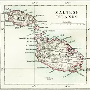
French chart of Malta, c.1798 (manuscript)
")
![]()
Wall Art and Photo Gifts from Fine Art Finder
French chart of Malta, c.1798 (manuscript)
7339445 French chart of Malta, c.1798 (manuscript) by Unknown artist, (18th century); 500x700 cm; National Maritime Museum, London, UK; (add.info.: Creator: unknown
Napoleon's forces overpowered Malta in June 1798 then departed for Egypt, leaving an occupying force behind. In September 1800 Nelson's fleet captured the island. Under the terms of the Treaty of Amiens, Malta was to be returned to the Order of St John and Britain's reluctance to comply was a factor leading to the resumption of war in 1803.); © National Maritime Museum, Greenwich, London
Media ID 38412662
© © National Maritime Museum, Greenwich, London / Bridgeman Images
Island Of Malta Malta Maltese Geographer
FEATURES IN THESE COLLECTIONS
> Arts
> Artists
> J
> John June
> Europe
> Malta
> Related Images
> Europe
> United Kingdom
> England
> London
> Boroughs
> Greenwich
> Europe
> United Kingdom
> England
> London
> Museums
> British Museum
> Fine Art Finder
> Artists
> Unknown Artist
EDITORS COMMENTS
This stunning French chart of Malta, dating back to around 1798, offers a fascinating glimpse into the historical geography of this Mediterranean island. Created by an unknown artist in the 18th century, this manuscript captures the intricate details of Malta's coastline and topography with remarkable precision.
During this period, Malta was a strategic stronghold that saw significant military activity. Napoleon's forces briefly occupied the island in 1798 before being ousted by Nelson's fleet in 1800. The Treaty of Amiens stipulated that Malta was to be returned to the Order of St John, but Britain's reluctance to comply ultimately led to the resumption of hostilities.
The vibrant colors and intricate cartographic details on this map showcase the artistry and skill of its creator. From coastal features to inland settlements, every aspect is meticulously rendered for both practical and aesthetic purposes.
Now housed at the National Maritime Museum in London, this French chart serves as a valuable historical artifact that sheds light on a pivotal moment in European history. It stands as a testament to the importance of cartography in understanding past events and shaping our knowledge of geographical landscapes.
MADE IN THE USA
Safe Shipping with 30 Day Money Back Guarantee
FREE PERSONALISATION*
We are proud to offer a range of customisation features including Personalised Captions, Color Filters and Picture Zoom Tools
SECURE PAYMENTS
We happily accept a wide range of payment options so you can pay for the things you need in the way that is most convenient for you
* Options may vary by product and licensing agreement. Zoomed Pictures can be adjusted in the Cart.