Home > Asia > Indonesia > Maps
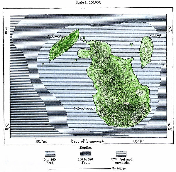
Geographic map of the volcano of Krakatoa and the surrounding islands (Lang and Verlaten island present-day Sertung) before the eruption of the volcano in 1883. Colour engraving of the 19th century
![]()

Wall Art and Photo Gifts from Fine Art Finder
Geographic map of the volcano of Krakatoa and the surrounding islands (Lang and Verlaten island present-day Sertung) before the eruption of the volcano in 1883. Colour engraving of the 19th century
NWI4879073 Geographic map of the volcano of Krakatoa and the surrounding islands (Lang and Verlaten island present-day Sertung) before the eruption of the volcano in 1883. Colour engraving of the 19th century.; (add.info.: Geographic map of the volcano of Krakatoa and the surrounding islands (Lang and Verlaten island present-day Sertung) before the eruption of the volcano in 1883. Colour engraving of the 19th century.); Photo © North Wind Pictures
Media ID 38422190
© © North Wind Pictures / Bridgeman Images
Indonesia Indonesia Indonesian Indonesian South East Asia Volcano Asian Asian Geographical Map
FEATURES IN THESE COLLECTIONS
> Asia
> Indonesia
> Related Images
> Fine Art Finder
> Artists
> Pasquier (workshop of) Grenier
> Maps and Charts
> Early Maps
> Popular Themes
> North Island
EDITORS COMMENTS
This stunning 19th-century color engraving captures the geographic map of the volcano of Krakatoa and the surrounding islands, including Lang and Verlaten Island (present-day Sertung), before the catastrophic eruption in 1883. The intricate details of this historical print provide a glimpse into the natural beauty and geographical features of this region in Southeast Asia.
The vibrant colors used in this engraving bring to life the lush landscapes and diverse topography of these islands, showcasing their unique characteristics before they were forever changed by one of the most powerful volcanic eruptions in recorded history. The careful craftsmanship of the engraver is evident in every line and curve, creating a visually captivating representation that transports viewers back in time.
As we gaze upon this mesmerizing image, we are reminded of the fragile balance between nature's beauty and its destructive power. The peaceful tranquility depicted in this map stands in stark contrast to the violent forces that would soon reshape this landscape, leaving behind a legacy that continues to fascinate scientists and historians to this day.
This historic print serves as a poignant reminder of both the resilience and vulnerability of our planet, urging us to cherish and protect our natural world for future generations to come.
MADE IN THE USA
Safe Shipping with 30 Day Money Back Guarantee
FREE PERSONALISATION*
We are proud to offer a range of customisation features including Personalised Captions, Color Filters and Picture Zoom Tools
SECURE PAYMENTS
We happily accept a wide range of payment options so you can pay for the things you need in the way that is most convenient for you
* Options may vary by product and licensing agreement. Zoomed Pictures can be adjusted in the Cart.


