Home > Arts > Artists > I > Irish School Irish School
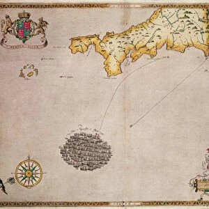
A new hydrographical survey of the British Channel, with part of the Atlantic Ocean as far as Cape Clear, improved from the large chart of the late Thomas Jeffery's Geographer to the King, 1781 (copperplate engraving)
")
![]()
Wall Art and Photo Gifts from Fine Art Finder
A new hydrographical survey of the British Channel, with part of the Atlantic Ocean as far as Cape Clear, improved from the large chart of the late Thomas Jeffery's Geographer to the King, 1781 (copperplate engraving)
7340129 A new hydrographical survey of the British Channel, with part of the Atlantic Ocean as far as Cape Clear, improved from the large chart of the late Thomas Jeffery's Geographer to the King, 1781 (copperplate engraving) by British School, (18th Century); 73.5x155.5 cm; National Maritime Museum, London, UK; (add.info.: Creator: Robert Sayer; John Bennett
This chart is bound in Sayer & Bennett's A Complete Channel Pilot, comprehending the English and French coasts, from the Thames Mouth to the Bay of Biscay, including the North Sea, with sailing directions. Copperplate engraving.); © National Maritime Museum, Greenwich, London
Media ID 38410172
© © National Maritime Museum, Greenwich, London / Bridgeman Images
Atlantic Atlantic Ocean British Channel English Channel
FEATURES IN THESE COLLECTIONS
> Arts
> Artists
> I
> Irish School Irish School
> Arts
> Artists
> J
> Thomas Jefferys
> Arts
> Artists
> N
> Thomas North
> Arts
> Artists
> O
> Oceanic Oceanic
> Arts
> Artists
> R
> Thomas Roberts
> Arts
> Artists
> W
> John White
> Arts
> Artists
> W
> Robert White
> Europe
> France
> Sport
> Sailing
> Europe
> Republic of Ireland
> Maps
> Fine Art Finder
> Artists
> British School
> Fine Art Finder
> Artists
> Robert (after) Adams
EDITORS COMMENTS
This stunning copperplate engraving from the 18th century showcases a new hydrographical survey of the British Channel, extending all the way to Cape Clear in the Atlantic Ocean. Created by Robert Sayer and John Bennett, this detailed chart was improved from the work of renowned geographer Thomas Jefferys, who served as Geographer to the King.
Bound in Sayer & Bennett's A Complete Channel Pilot, this engraving provides sailing directions for navigating both English and French coasts, spanning from the Thames Mouth to the Bay of Biscay. The intricate lines and markings on this map offer a glimpse into maritime navigation during this era.
As you study this historical piece, you can't help but marvel at the precision and artistry involved in its creation. The black-and-white contrast adds a sense of elegance to the composition, highlighting every detail with clarity.
Transport yourself back in time with this print that not only serves as a navigational tool but also as a work of art. Explore the waters of Europe through the eyes of 18th-century cartographers and immerse yourself in an era where exploration and discovery were paramount.
MADE IN THE USA
Safe Shipping with 30 Day Money Back Guarantee
FREE PERSONALISATION*
We are proud to offer a range of customisation features including Personalised Captions, Color Filters and Picture Zoom Tools
SECURE PAYMENTS
We happily accept a wide range of payment options so you can pay for the things you need in the way that is most convenient for you
* Options may vary by product and licensing agreement. Zoomed Pictures can be adjusted in the Cart.