Home > Historic > Ancient civilizations > Ancient Greece > Greek history
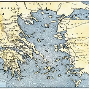
Map of Greece (Thessaly, Peloponnese and Cycladic Islands), circa 1870. 19th century lithography
, circa 1870. 19th century lithography")
![]()
Wall Art and Photo Gifts from Fine Art Finder
Map of Greece (Thessaly, Peloponnese and Cycladic Islands), circa 1870. 19th century lithography
NWI4871595 Map of Greece (Thessaly, Peloponnese and Cycladic Islands), circa 1870. 19th century lithography.; (add.info.: Map of Greece (Thessaly, Peloponnese and Cycladic Islands), circa 1870. 19th century lithography.); Photo © North Wind Pictures
Media ID 38335550
© © North Wind Pictures / Bridgeman Images
Cyclades Islands Geographical Map Grece Greece Greek
FEATURES IN THESE COLLECTIONS
> Europe
> Greece
> Related Images
> Fine Art Finder
> Artists
> Spanish School (after)
> Historic
> Ancient civilizations
> Ancient Greece
> Greek history
> Maps and Charts
> Early Maps
> Popular Themes
> North Island
EDITORS COMMENTS
This stunning lithograph print from circa 1870 showcases a detailed map of Greece, specifically highlighting the regions of Thessaly, Peloponnese, and the Cycladic Islands. The intricate lines and vibrant colors bring this 19th-century cartographic masterpiece to life, offering a glimpse into the geographical landscape of Greece during that era.
The map not only serves as a visual representation of the country's topography but also provides insight into its historical significance. From the mountainous terrain of Thessaly to the picturesque islands of Cyclades, each region is meticulously depicted with precision and accuracy.
As we gaze upon this vintage lithograph, we are transported back in time to an age where cartography was both an art form and a scientific endeavor. The attention to detail in capturing every contour and coastline reflects the dedication and skill of the engraver who painstakingly created this work of art.
Whether you are a history buff, geography enthusiast, or simply appreciate fine craftsmanship, this Map of Greece is sure to captivate your imagination. It serves as a reminder of the rich cultural heritage and natural beauty that defines this ancient land known for its myths, legends, and enduring legacy.
MADE IN THE USA
Safe Shipping with 30 Day Money Back Guarantee
FREE PERSONALISATION*
We are proud to offer a range of customisation features including Personalised Captions, Color Filters and Picture Zoom Tools
SECURE PAYMENTS
We happily accept a wide range of payment options so you can pay for the things you need in the way that is most convenient for you
* Options may vary by product and licensing agreement. Zoomed Pictures can be adjusted in the Cart.