Home > Arts > Art Movements > Related Images
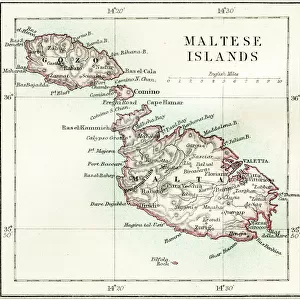
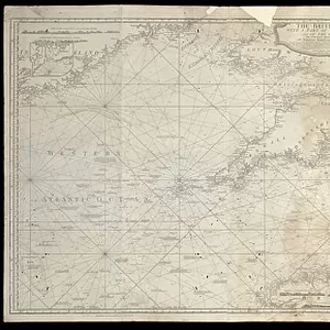
The British Channel with a part of the Atlantic Ocean and of the Coast of Ireland, 1788 (print)
")
![]()
Wall Art and Photo Gifts from Fine Art Finder
The British Channel with a part of the Atlantic Ocean and of the Coast of Ireland, 1788 (print)
7340084 The British Channel with a part of the Atlantic Ocean and of the Coast of Ireland, 1788 (print) by Sayer, Robert (1724/5-94); 44.2x92.9 cm; National Maritime Museum, London, UK; (add.info.: Creator: Robert Sayer
Atlas-bound chart with annotations. Used on 'Bellerophon', showing movements of Nelson's squadron while searching for French fleet. It probably belonged to her captain, Henry Darby.
This chart of the Mediterranean Sea was used to record 'Bellerophon's' track. A manuscript note in the lower margin records: 'At 2 [p.m. on 1 August 1798] the French fleet consisting of 13 Sail of the Line & 4 Frigates were seen at Anchor between Alexandria & Rosetta. ¼ before sunset the Action began.'
Darby in 'Bellerophon', a 74-gun ship, took on the French flagship, the 120-gun 'L'Orient' which blew up at 10 p.m. 'Bellerophon' suffered 49 killed and 148 wounded, including Captain Darby who received a head wound. After the battle, 'Bellerophon' limped to Malta and from there to Gibraltar for repairs.); © National Maritime Museum, Greenwich, London
Media ID 38371946
© © National Maritime Museum, Greenwich, London / Bridgeman Images
Atlantic Atlantic Ocean British Channel Coast Line English Channel Ireland Irish
FEATURES IN THESE COLLECTIONS
> Arts
> Art Movements
> Related Images
> Arts
> Artists
> W
> Robert White
> Europe
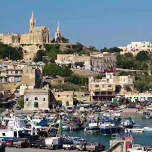
> Malta
> Related Images
> Europe
> Republic of Ireland
> Maps
> Europe
> United Kingdom
> England
> London
> Boroughs
> Greenwich
> Europe
> United Kingdom
> England
> London
> Museums
> British Museum
> Europe
> United Kingdom
> England
> London
> Museums
> Greenwich Heritage Centre
> Fine Art Finder
> Artists
> Robert Sayer
> Fine Art Finder
> Artists
> Sydney Hall
EDITORS COMMENTS
This stunning print captures the beauty and historical significance of The British Channel, a vital waterway connecting the Atlantic Ocean to the coast of Ireland. Created in 1788 by Robert Sayer, this detailed chart was used on the HMS Bellerophon during Admiral Nelson's search for the French fleet.
The annotations on this atlas-bound chart provide a glimpse into the movements of Nelson's squadron as they navigated these treacherous waters. The manuscript note in the lower margin recounts a pivotal moment in history when the French fleet was spotted near Alexandria, leading to a fierce battle that resulted in significant casualties on both sides.
One can imagine Captain Henry Darby consulting this chart as he led his ship, 'Bellerophon', into battle against the formidable French flagship, 'L'Orient'. Despite sustaining heavy losses and damage to their own vessel, 'Bellerophon' emerged victorious and continued its journey to Malta and Gibraltar for much-needed repairs.
This print serves as a reminder of the bravery and skill displayed by sailors like Captain Darby and his crew as they braved the unpredictable seas of The British Channel. It is not just a map but a piece of history preserved for future generations to admire and learn from.
MADE IN THE USA
Safe Shipping with 30 Day Money Back Guarantee
FREE PERSONALISATION*
We are proud to offer a range of customisation features including Personalised Captions, Color Filters and Picture Zoom Tools
SECURE PAYMENTS
We happily accept a wide range of payment options so you can pay for the things you need in the way that is most convenient for you
* Options may vary by product and licensing agreement. Zoomed Pictures can be adjusted in the Cart.