Home > Europe > United Kingdom > England > London > Museums > National Maritime Museum
Chart of Mediterranean, Black and Caspian Seas, c.1620 (manuscript)
")
![]()
Wall Art and Photo Gifts from Fine Art Finder
Chart of Mediterranean, Black and Caspian Seas, c.1620 (manuscript)
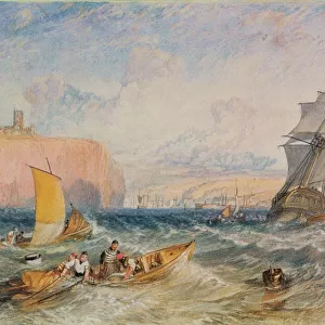
7339783 Chart of Mediterranean, Black and Caspian Seas, c.1620 (manuscript) by Unknown Artist, (17th century); 41x60 cm; National Maritime Museum, London, UK; (add.info.: Creator: unknown
This type of early vellum sea chart originated in the Mediterranean in the 13th century. They are often referred to as 'portulan' or 'portolan' charts, a name taken from the written sailing directions, 'portolani', which they supplemented and superseded, although this attribution is not always technically correct. They were drawn in coloured ink on vellum.); © National Maritime Museum, Greenwich, London
Media ID 38372720
© © National Maritime Museum, Greenwich, London / Bridgeman Images
Black Sea Mediterranea Mediterranean Mediterranean Sea Mediterrean Mediterrean Sea Meditteranean
FEATURES IN THESE COLLECTIONS
> Europe
> France
> Sport
> Sailing
> Europe
> United Kingdom
> England
> London
> Boroughs
> Greenwich
> Europe
> United Kingdom
> England
> London
> Museums
> Greenwich Heritage Centre
> Europe
> United Kingdom
> England
> London
> Museums
> National Maritime Museum
> Europe
> United Kingdom
> England
> London
> Sport
> Sailing
> Europe
> United Kingdom
> England
> London
> Towns
> Greenwich
> Europe
> United Kingdom
> Heritage Sites
> Maritime Greenwich
> Europe
> United Kingdom
> Maps
> Fine Art Finder
> Artists
> Thomas Baxter
> Fine Art Finder
> Artists
> Unknown Artist
> Maps and Charts
> Early Maps
EDITORS COMMENTS
This stunning manuscript print of a Chart of Mediterranean, Black and Caspian Seas from around 1620 is a true masterpiece of early cartography. Created by an unknown artist in the 17th century, this intricate sea chart showcases the detailed knowledge and skill of navigators during this time period.
The use of vellum as the medium for this map adds to its historical significance, as vellum sea charts like these originated in the Mediterranean in the 13th century. Often referred to as 'portulan' or 'portolan' charts, they were essential tools for sailors navigating the treacherous waters of these seas.
The vibrant colors used on this chart bring it to life, highlighting important coastal features and navigational markers. The inclusion of written sailing directions known as 'portolani' further enhances its utility for seafarers seeking safe passage through these waters.
Displayed at the National Maritime Museum in London, UK, this piece serves as a reminder of the rich history and legacy of maritime exploration and navigation. It stands as a testament to human ingenuity and perseverance in mapping out our world's oceans centuries ago.
MADE IN THE USA
Safe Shipping with 30 Day Money Back Guarantee
FREE PERSONALISATION*
We are proud to offer a range of customisation features including Personalised Captions, Color Filters and Picture Zoom Tools
SECURE PAYMENTS
We happily accept a wide range of payment options so you can pay for the things you need in the way that is most convenient for you
* Options may vary by product and licensing agreement. Zoomed Pictures can be adjusted in the Cart.