Home > Europe > Italy > Veneto > Venice
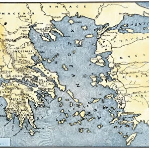
Geographical map of Italy. Miniature from the 15th century, based on the manuscript Geographia (Geography) by Claudius Ptolemaeus (Claudius Ptolemaeus, 90-168). Greek translation. Ref: MS Gr. S.388 (33) FF. 5V°-6R°
 by Claudius Ptolemaeus (Claudius Ptolemaeus, 90-168). Greek translation. Ref: MS Gr. S.388 (33) FF. 5V°-6R°")
![]()
Wall Art and Photo Gifts from Fine Art Finder
Geographical map of Italy. Miniature from the 15th century, based on the manuscript Geographia (Geography) by Claudius Ptolemaeus (Claudius Ptolemaeus, 90-168). Greek translation. Ref: MS Gr. S.388 (33) FF. 5V°-6R°
BEN5469694 Geographical map of Italy. Miniature from the 15th century, based on the manuscript Geographia (Geography) by Claudius Ptolemaeus (Claudius Ptolemaeus, 90-168). Greek translation. Ref: MS Gr. S.388 (33) FF. 5V°-6R°. Biblioteca Nazionale Marciana, Venezia (Marciana Library, Venice).; Photo © Raffaello Bencini
Media ID 38436688
© © Raffaello Bencini / Bridgeman Images
15eme Siecle Astrologer Astrologue Astronome Astronomer Astronomers Astronomie Claudius Ptolemaeus Claudius Ptolemy Enluminure Geographie Illumnation Islands Isles Italie Ptolemy Seawater 15th 15 Xv Xvth Fifteenth Century Geographer
FEATURES IN THESE COLLECTIONS
> Europe
> Greece
> Related Images
> Europe
> Italy
> Veneto
> Venice
> Fine Art Finder
> Artists
> Thomas Garner
> Historic
> Ancient civilizations
> Ancient Greece
> Greek history
> Maps and Charts
> Italy
EDITORS COMMENTS
This stunning print showcases a miniature geographical map of Italy from the 15th century, based on the manuscript 'Geographia' by Claudius Ptolemaeus. The intricate details and vibrant colors bring to life the ancient Greek translation of this historical work.
The map is a true masterpiece, highlighting Italy's diverse landscapes, coastlines, and islands with precision and artistry. It offers a glimpse into the knowledge and skills of cartographers during this period, as well as the importance of geography in understanding the world.
Displayed in the Marciana Library in Venice, this piece is not just a representation of Italy but also a reflection of European exploration and discovery. It symbolizes the interconnectedness of cultures through trade routes across seas and oceans.
As we admire this artwork, we are transported back in time to an era when maps were not only tools for navigation but also works of art that captured people's imaginations. The combination of science and creativity in this map reminds us of the beauty found in both nature and human ingenuity.
Overall, this print serves as a reminder of our shared history and interconnectedness as global citizens. It invites us to appreciate the rich tapestry of cultures that have shaped our world over centuries.
MADE IN THE USA
Safe Shipping with 30 Day Money Back Guarantee
FREE PERSONALISATION*
We are proud to offer a range of customisation features including Personalised Captions, Color Filters and Picture Zoom Tools
SECURE PAYMENTS
We happily accept a wide range of payment options so you can pay for the things you need in the way that is most convenient for you
* Options may vary by product and licensing agreement. Zoomed Pictures can be adjusted in the Cart.