Home > Europe > United Kingdom > England > London > Museums > National Maritime Museum
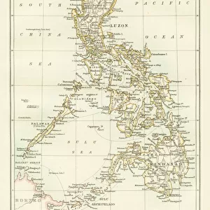
A chart of the channel in the Phillippine Islands through which the Manila Galeon passes together with the adjacent islands, 1748 (engraving)
")
![]()
Wall Art and Photo Gifts from Fine Art Finder
A chart of the channel in the Phillippine Islands through which the Manila Galeon passes together with the adjacent islands, 1748 (engraving)
7339387 A chart of the channel in the Phillippine Islands through which the Manila Galeon passes together with the adjacent islands, 1748 (engraving) by Seale, Richard William (fl.1732-75); 75.5x55.5 cm; National Maritime Museum, London, UK; (add.info.: Creator: RW Seale
Single sheet. Engr. Scale: [ca.1:1 500 000]. Cartographic Note: Border graduated for latitude. Rhumb lines. Additional Places: Luzon. In June 1743 Anson redeemed his disastrous voyage by capturing the Acapulco treasure galleon as it sailed in to Manila. He lay in wait at Capo de Espiritu Santo.); © National Maritime Museum, Greenwich, London
Media ID 38339578
© © National Maritime Museum, Greenwich, London / Bridgeman Images
Filipino Islands Isles Philippines Phillippine South East Asia Asiae
FEATURES IN THESE COLLECTIONS
> Animals
> Insects
> Hemiptera
> Black Scale
> Arts
> Artists
> W
> William White
> Asia
> Philippines
> Manila
> Asia
> Philippines
> Maps
> Asia
> Philippines
> Related Images
> Europe
> United Kingdom
> England
> London
> Boroughs
> Greenwich
> Europe
> United Kingdom
> England
> London
> Museums
> Greenwich Heritage Centre
> Europe
> United Kingdom
> England
> London
> Museums
> National Maritime Museum
> Europe
> United Kingdom
> England
> London
> Towns
> Greenwich
> Europe
> United Kingdom
> Heritage Sites
> Maritime Greenwich
> Fine Art Finder
> Artists
> Richard William Seale
> Fine Art Finder
> Artists
> Unknown Artist
EDITORS COMMENTS
This stunning engraving from 1748 depicts a chart of the channel in the Philippine Islands through which the Manila Galeon passes, along with the adjacent islands. Created by Richard William Seale, this intricate map showcases the detailed cartography and navigational aids used during that time period.
The border of the map is graduated for latitude, with rhumb lines indicating direction for sailors. The main focus is on Luzon, one of the largest islands in the Philippines. In June 1743, Admiral Anson made history by capturing the Acapulco treasure galleon as it sailed into Manila while waiting at Capo de Espiritu Santo.
This historical piece provides a glimpse into early 18th-century navigation and exploration in Asia. The black-and-white engraving captures not only geographical information but also reflects the artistry and skill of its creator.
Displayed at the National Maritime Museum in London, this print serves as a reminder of a bygone era when seafaring was both treacherous and adventurous. It stands as a testament to human ingenuity and perseverance in mapping out uncharted territories and navigating through unknown waters.
MADE IN THE USA
Safe Shipping with 30 Day Money Back Guarantee
FREE PERSONALISATION*
We are proud to offer a range of customisation features including Personalised Captions, Color Filters and Picture Zoom Tools
SECURE PAYMENTS
We happily accept a wide range of payment options so you can pay for the things you need in the way that is most convenient for you
* Options may vary by product and licensing agreement. Zoomed Pictures can be adjusted in the Cart.