Home > Europe > United Kingdom > England > London > Museums > National Maritime Museum
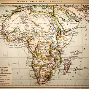
Chart of the Guinea coast, Manicongo and Angola as far as the Cape of Good Hope, 1596 (coloured engraving)
")
![]()
Wall Art and Photo Gifts from Fine Art Finder
Chart of the Guinea coast, Manicongo and Angola as far as the Cape of Good Hope, 1596 (coloured engraving)
7339482 Chart of the Guinea coast, Manicongo and Angola as far as the Cape of Good Hope, 1596 (coloured engraving) by Davis, L. (19th century); 39x53 cm; National Maritime Museum, London, UK; (add.info.: Creator: A.F. van Langren
From Linschoten's Itinerio, first published in Amsterdam in 1596. Inset views of Ascension Island and St Helena, set in an elaborate frame. Title cartouche with birds, fruit and scroll-work. Sea decorated with ships and a sea-creature. Land decorated with animals; mythical triton and siren in Lake of Zaire.); © National Maritime Museum, Greenwich, London
Media ID 38509944
© © National Maritime Museum, Greenwich, London / Bridgeman Images
FEATURES IN THESE COLLECTIONS
> Africa
> Angola
> Related Images
> Africa
> Guinea
> Related Images
> Africa
> Related Images
> Europe
> France
> Canton
> Landes
> Europe
> United Kingdom
> England
> London
> Boroughs
> Greenwich
> Europe
> United Kingdom
> England
> London
> Museums
> Greenwich Heritage Centre
> Europe
> United Kingdom
> England
> London
> Museums
> National Maritime Museum
> Europe
> United Kingdom
> England
> London
> Towns
> Greenwich
> Fine Art Finder
> Artists
> L. Davis
> Fine Art Finder
> Artists
> Unknown Artist
EDITORS COMMENTS
This stunning coloured engraving from 1596 depicts a detailed Chart of the Guinea coast, Manicongo and Angola as far as the Cape of Good Hope. Created by A.F. van Langren and featured in Linschoten's 'Itinerio', this intricate map showcases inset views of Ascension Island and St Helena within an elaborate frame.
The title cartouche is adorned with birds, fruit, and scroll-work, while the sea is decorated with ships and a mysterious sea-creature. The land features various animals, including a mythical triton and siren in Lake of Zaire.
This historical piece of cartography not only serves as a navigational tool but also offers a glimpse into the artistic style of the 16th century. The vibrant colours used in this engraving bring to life the African coastline, highlighting its beauty and complexity.
As you study this map closely, you can appreciate the attention to detail put forth by the engraver Davis, L., capturing both geographical accuracy and imaginative elements such as mythical creatures. This print from the National Maritime Museum in London is truly a treasure trove for history enthusiasts and art lovers alike.
MADE IN THE USA
Safe Shipping with 30 Day Money Back Guarantee
FREE PERSONALISATION*
We are proud to offer a range of customisation features including Personalised Captions, Color Filters and Picture Zoom Tools
SECURE PAYMENTS
We happily accept a wide range of payment options so you can pay for the things you need in the way that is most convenient for you
* Options may vary by product and licensing agreement. Zoomed Pictures can be adjusted in the Cart.