Home > Europe > United Kingdom > England > London > Museums > National Maritime Museum
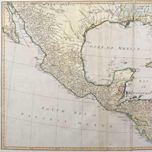
The Virgin Islands from English and Danish surveys, 1775 (engraving)
")
![]()
Wall Art and Photo Gifts from Fine Art Finder
The Virgin Islands from English and Danish surveys, 1775 (engraving)
7340498 The Virgin Islands from English and Danish surveys, 1775 (engraving) by Jefferys, Thomas (c.1719-71); 46.5x62 cm; National Maritime Museum, London, UK; (add.info.: Creator: Thomas Jefferys
Scale: circa 1:500 000, with cartographic note: Graduated, meridians of London and Ferro. Scales are in sea leagues and statute miles, it shows the Caribbean and twelve views. The text box describes the settlement history of the islands, The current population was chiefly English from Nevis and Antigua and Irish papists'.
Thomas Jefferys was Geographer to George III and he died in 1771 so this map was published posthumously.); © National Maritime Museum, Greenwich, London
Media ID 38519442
© © National Maritime Museum, Greenwich, London / Bridgeman Images
FEATURES IN THESE COLLECTIONS
> Arts
> Artists
> J
> Thomas Jefferys
> Europe
> Denmark
> Related Images
> Europe
> Republic of Ireland
> Maps
> Europe
> United Kingdom
> England
> London
> Boroughs
> Greenwich
> Europe
> United Kingdom
> England
> London
> Museums
> British Museum
> Europe
> United Kingdom
> England
> London
> Museums
> Greenwich Heritage Centre
> Europe
> United Kingdom
> England
> London
> Museums
> National Maritime Museum
> Europe
> United Kingdom
> England
> London
> Sights
> British Museum
> Fine Art Finder
> Artists
> Thomas Jefferys
> Fine Art Finder
> Artists
> Unknown Artist
EDITORS COMMENTS
This stunning engraving from 1775 captures the beauty and historical significance of The Virgin Islands, as seen through the meticulous surveys conducted by English and Danish explorers. Created by Thomas Jefferys, Geographer to George III, this map provides a detailed view of the Caribbean islands with twelve accompanying views.
The intricate details on this print showcase the settlement history of The Virgin Islands, noting that the population at that time was predominantly English from Nevis and Antigua, along with Irish papists. The scale of approximately 1:500,000 allows for a comprehensive understanding of the geography and topography of these islands.
Published posthumously after Jefferys' death in 1771, this engraving serves as a valuable historical artifact that sheds light on the colonial influences in the region during the 18th century. The use of sea leagues and statute miles for measurement adds to its cartographic significance.
Whether you are a history enthusiast or simply appreciate fine art, this print is sure to captivate your imagination with its blend of precision and aesthetic appeal. Explore The Virgin Islands through the eyes of early explorers with this remarkable piece from National Maritime Museum in London.
MADE IN THE USA
Safe Shipping with 30 Day Money Back Guarantee
FREE PERSONALISATION*
We are proud to offer a range of customisation features including Personalised Captions, Color Filters and Picture Zoom Tools
SECURE PAYMENTS
We happily accept a wide range of payment options so you can pay for the things you need in the way that is most convenient for you
* Options may vary by product and licensing agreement. Zoomed Pictures can be adjusted in the Cart.