Home > Animals > Insects > Hemiptera > Black Scale
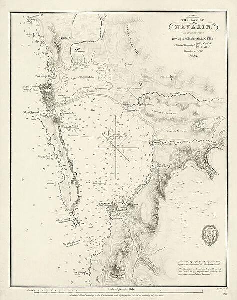
Bay of Navarino, 1830 (print)
![]()

Wall Art and Photo Gifts from Fine Art Finder
Bay of Navarino, 1830 (print)
7340652 Bay of Navarino, 1830 (print) by Smyth, William Henry (1788-1865); 32.5x25.5 cm; National Maritime Museum, London, UK; (add.info.: Creator: Captain William Henry Smyth
Chart titled The Bay of Navarin... the chart is Admiralty Number 211, has a scale calculated at 1:35, 000. The chart is bound in an untitled atlas published by the British Admiralty (Hydrographic Office) in 1851, and is one of 45 printed charts covering Europe and Asia Minor, including Smyth's surveys of Sicily, Malta and the adjacent islands.); © National Maritime Museum, Greenwich, London
Media ID 38519428
© © National Maritime Museum, Greenwich, London / Bridgeman Images
FEATURES IN THESE COLLECTIONS
> Animals
> Insects
> Hemiptera
> Black Scale
> Arts
> Artists
> W
> William White
> Europe
> Greece
> Related Images
> Europe
> Italy
> Sicily
> Related Images
> Europe
> Malta
> Related Images
> Europe
> United Kingdom
> England
> London
> Boroughs
> Greenwich
> Fine Art Finder
> Artists
> William Henry Smyth
EDITORS COMMENTS
This stunning print of the Bay of Navarino, created by Captain William Henry Smyth in 1830, captures the beauty and intricacy of cartography in the 19th century. The chart titled 'The Bay of Navarin' is a testament to Smyth's meticulous surveys of Sicily, Malta, and adjacent islands, showcasing his dedication to precision and detail.
Admiralty Number 211, with a scale calculated at 1:35,000, this print is part of an untitled atlas published by the British Admiralty (Hydrographic Office) in 1851. It is one of 45 printed charts covering Europe and Asia Minor, highlighting Smyth's expertise in mapping coastal regions with accuracy.
The black and white composition adds a timeless quality to this piece, allowing viewers to appreciate the historical significance of Smyth's work in documenting maritime landscapes. The intricate lines and markings on the map reveal not only geographical features but also cultural connections between Greece and other European nations during this period.
As we gaze upon this print from the National Maritime Museum in London, we are transported back to a time when exploration and discovery were at the forefront of human endeavor. This image serves as a reminder of our enduring fascination with maps as tools for understanding our world.
MADE IN THE USA
Safe Shipping with 30 Day Money Back Guarantee
FREE PERSONALISATION*
We are proud to offer a range of customisation features including Personalised Captions, Color Filters and Picture Zoom Tools
SECURE PAYMENTS
We happily accept a wide range of payment options so you can pay for the things you need in the way that is most convenient for you
* Options may vary by product and licensing agreement. Zoomed Pictures can be adjusted in the Cart.

