Home > Europe > France > Maps
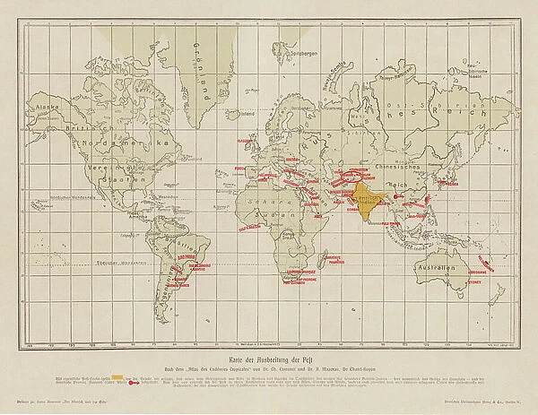
World map showing the spread of the plague (colour litho)
![]()

Wall Art and Photo Gifts from Fine Art Finder
World map showing the spread of the plague (colour litho)
8663630 World map showing the spread of the plague (colour litho) by French School, (20th century); Private Collection; (add.info.: World map showing the spread of the plague. Illustration for Der Mensch und die Erde by Hans Kraemer (Deutsches Verlagshaus Bong, 1906-1913).); © Look and Learn
Media ID 38378266
© © Look and Learn / Bridgeman Images
Ailment Bubonic Plague Contagion Disease Epidemic Illness Pandemic Plague Plague Of Plague Victim Plagues Sick Sickness Geographer
FEATURES IN THESE COLLECTIONS
> Fine Art Finder
> Artists
> French School
> Fine Art Finder
> Artists
> Walter Frederick Roofe Tyndale
> Maps and Charts
> Early Maps
> Maps and Charts
> World
EDITORS COMMENTS
This striking color lithograph from the 20th century depicts a World map showing the spread of the plague, a devastating epidemic that ravaged populations throughout history. The intricate details and vibrant colors bring to life the geographical impact of this contagious disease, highlighting its widespread reach across continents.
Created by French School artists, this print is part of a series illustrating Hans Kraemer's book "Der Mensch und die Erde," published between 1906-1913. The visual representation of the plague's progression serves as a powerful reminder of the importance of understanding and combating infectious diseases in our global society.
The depiction of plague victims and medical symbols on the map adds depth to its narrative, emphasizing both the human toll and scientific efforts to combat such outbreaks. As viewers engage with this historical artwork, they are transported back in time to an era when public health crises posed significant challenges to communities worldwide.
Through artistry and storytelling, this World map showcasing the spread of the plague invites reflection on past pandemics while underscoring the ongoing relevance of public health measures in safeguarding against future threats. It stands as a testament to resilience in times of crisis and serves as a poignant reminder of our interconnectedness as inhabitants of planet Earth.
MADE IN THE USA
Safe Shipping with 30 Day Money Back Guarantee
FREE PERSONALISATION*
We are proud to offer a range of customisation features including Personalised Captions, Color Filters and Picture Zoom Tools
SECURE PAYMENTS
We happily accept a wide range of payment options so you can pay for the things you need in the way that is most convenient for you
* Options may vary by product and licensing agreement. Zoomed Pictures can be adjusted in the Cart.


