Home > Africa > Guinea > Maps
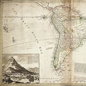
Map of Africa, c.1715 (coloured engraving)
")
![]()
Wall Art and Photo Gifts from Fine Art Finder
Map of Africa, c.1715 (coloured engraving)
7339356 Map of Africa, c.1715 (coloured engraving) by Moll, Hermann (fl.1678-1732); 60x99 cm; National Maritime Museum, London, UK; (add.info.: Creator: Herman Moll
Single sheet. Hand col. engr. Medium: 2 pieces of paper, joined at centre, linen backed. Scale: [ca. 1:12 000 000]. Cartographic Note: Graduated chart, meridians of London and Ferro. Wind directions shown. Contents Note: Title cartouche with Africans and wild animals, Insets 1. Cape Coast Castle on ye Gold Coast of Guinea, 2. James Fort on the Island of St. Helena, 3. Fort of Good Hope, 4. A Prospect of the Cape of Good Hope, Inscribed To the Right Honourable Charles Earl of Peterborow and Monmouth &c This map of Africa according to ye Newest and Most Exact Observations'. Recommended tract for sailing from Britain to the East Indies.); © National Maritime Museum, Greenwich, London
Media ID 38409002
© © National Maritime Museum, Greenwich, London / Bridgeman Images
Africa African African Geographer
FEATURES IN THESE COLLECTIONS
> Africa
> Guinea
> Related Images
> Africa
> Related Images
> Arts
> Artists
> C
> James Charles
> Arts
> Artists
> G
> Charles Gold
> Arts
> Artists
> H
> James Hope
> Arts
> Artists
> M
> Herman Moll
> Europe
> United Kingdom
> England
> London
> Boroughs
> Greenwich
> Europe
> United Kingdom
> England
> London
> Museums
> British Museum
> Europe
> United Kingdom
> England
> London
> Museums
> Greenwich Heritage Centre
> Fine Art Finder
> Artists
> Hermann Moll
> Fine Art Finder
> Artists
> William Faden
EDITORS COMMENTS
This stunning print of a Map of Africa, dating back to around 1715, offers a fascinating glimpse into the cartographic knowledge and artistic style of the early 18th century. Created by Herman Moll, a renowned geographer and engraver of his time, this coloured engraving showcases intricate details and vibrant hues that bring the continent to life.
Measuring 60x99 cm and housed at the National Maritime Museum in London, UK, this map features various insets highlighting key locations such as Cape Coast Castle on the Gold Coast of Guinea and James Fort on the Island of St. Helena. The title cartouche is adorned with depictions of Africans and wild animals, adding an element of cultural richness to the piece.
With wind directions indicated and a recommended sailing tract from Britain to the East Indies included, this map served both practical navigational purposes and aesthetic appreciation. The dedication inscribed to Charles Earl of Peterborow adds a touch of historical significance to this already remarkable artwork.
Overall, this Map of Africa from c.1715 is not just a geographical representation but also a work of art that encapsulates the spirit of exploration and discovery prevalent during that era. It stands as a testament to human curiosity and ingenuity in mapping out our world.
MADE IN THE USA
Safe Shipping with 30 Day Money Back Guarantee
FREE PERSONALISATION*
We are proud to offer a range of customisation features including Personalised Captions, Color Filters and Picture Zoom Tools
SECURE PAYMENTS
We happily accept a wide range of payment options so you can pay for the things you need in the way that is most convenient for you
* Options may vary by product and licensing agreement. Zoomed Pictures can be adjusted in the Cart.