Home > Europe > United Kingdom > England > London > Museums > National Maritime Museum
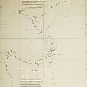
Roughly sketched chart of Wreck Reef 1803 from a collection of technical memoranda and correspondence from the Admiralty, 1812-1814 FLI/7/22 (drawing)
")
![]()
Wall Art and Photo Gifts from Fine Art Finder
Roughly sketched chart of Wreck Reef 1803 from a collection of technical memoranda and correspondence from the Admiralty, 1812-1814 FLI/7/22 (drawing)
7340789 Roughly sketched chart of Wreck Reef 1803 from a collection of technical memoranda and correspondence from the Admiralty, 1812-1814 FLI/7/22 (drawing) by Flinders, Matthew (1774-1814); National Maritime Museum, London, UK; (add.info.: Creator: Flinders, Matthew
Technical memoranda and correspondence from the Admiralty, mainly on variation of the compass, and copies of articles on his voyage published in contemporary periodicals in Malay vocabulary and alphabet, 1812-1814. There is also a sketched chart of Wreck Reef numbered FLI/7/22.); © National Maritime Museum, Greenwich, London
Media ID 38409920
© © National Maritime Museum, Greenwich, London / Bridgeman Images
Islands Isles Malaysia Malaysian Preparatory Drawing Preparatory Sketch Ship Wreck Ship Wrecked Shipwreck Shipwrecked South East Asia Study Drawing Asiae
FEATURES IN THESE COLLECTIONS
> Arts
> Artists
> B
> Matthew Black
> Arts
> Contemporary art
> Arts
> Pop art
> Contemporary art
> Contemporary art gallery
> Arts
> Pop art
> Contemporary art
> Fine art gallery
> Asia
> Malaysia
> Related Images
> Europe
> United Kingdom
> England
> London
> Boroughs
> Greenwich
> Europe
> United Kingdom
> England
> London
> Museums
> Greenwich Heritage Centre
> Europe
> United Kingdom
> England
> London
> Museums
> National Maritime Museum
> Europe
> United Kingdom
> England
> London
> Towns
> Greenwich
> Fine Art Finder
> Artists
> Matthew Flinders
> Fine Art Finder
> Artists
> William Heath Robinson
EDITORS COMMENTS
This roughly sketched chart of 'Wreck Reef' from 1803 is a fascinating glimpse into the navigational challenges faced by sailors in the early 19th century. Created by Matthew Flinders, a renowned explorer and cartographer, this drawing is part of a collection of technical memoranda and correspondence from the Admiralty dating back to 1812-1814.
The intricate details captured in this sketch provide valuable insights into the art of cartography during that time period. The precision and accuracy required to map out dangerous reefs like Wreck Reef highlight the skill and expertise of Flinders as he documented uncharted territories for future generations.
As we study this historical artifact, we are transported back to an era where exploration was at its peak and seafarers relied on hand-drawn maps to navigate treacherous waters. The black-and-white composition adds a sense of nostalgia, reminding us of the challenges faced by sailors who braved unknown seas in search of new discoveries.
This drawing serves as a reminder of the importance of preserving our maritime heritage and honoring those who paved the way for modern navigation techniques. It is a testament to human ingenuity and determination in overcoming obstacles to explore the vast unknown expanses of our planet.
MADE IN THE USA
Safe Shipping with 30 Day Money Back Guarantee
FREE PERSONALISATION*
We are proud to offer a range of customisation features including Personalised Captions, Color Filters and Picture Zoom Tools
SECURE PAYMENTS
We happily accept a wide range of payment options so you can pay for the things you need in the way that is most convenient for you
* Options may vary by product and licensing agreement. Zoomed Pictures can be adjusted in the Cart.