Home > North America > Martinique > Maps
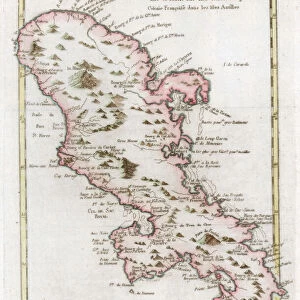
Map of Martinique, c.1900 (engraving)
")
![]()
Wall Art and Photo Gifts from Fine Art Finder
Map of Martinique, c.1900 (engraving)
533483 Map of Martinique, c.1900 (engraving); (add.info.: Map of Martinique, circa 1902, from the 10th edition of Encyclopaedia Britannica.); Encyclopaedia Britannica/UIG
Media ID 38094688
© Encyclopaedia Britannica/UIG / Bridgeman Images
1902 19th Century Style Caribbean Caribbean Island Caribbean Sea Cut Out Guidance Illustration Technique Martinique Meridian Navigational Equipment Number Old Fashioned Physical Geography The Past Western Script White Background
FEATURES IN THESE COLLECTIONS
> Fine Art Finder
> Greek Antiquities & Sites
> Fine Art Finder
> Temp Classification
> North America
> Martinique
> Maps
> North America
> Martinique
> Related Images
EDITORS COMMENTS
This stunning engraving of a Map of Martinique from around 1900 is a captivating piece that transports us back in time to the era of exploration and discovery. The intricate details and old-fashioned style of cartography give us a glimpse into the past, showcasing the island's physical geography with precision and artistry.
The map, originally featured in the 10th edition of Encyclopaedia Britannica, captures the essence of Martinique with its coastline, meridians, and navigational equipment. It serves as both a practical tool for guidance and an artistic representation of this beautiful Caribbean island.
As we study this vintage map, we can imagine early explorers using it to navigate the seas and uncover new lands. The Western script adds to its historical charm, reminding us of a time when maps were essential for understanding our world.
With its white background and detailed illustration technique, this print is not just a map but also a work of art. It invites us to appreciate the craftsmanship and dedication that went into creating such intricate pieces before modern technology took over.
Overall, this Map of Martinique from c.1900 is more than just a geographical representation – it's a window into history that allows us to connect with the past in a tangible way.
MADE IN THE USA
Safe Shipping with 30 Day Money Back Guarantee
FREE PERSONALISATION*
We are proud to offer a range of customisation features including Personalised Captions, Color Filters and Picture Zoom Tools
SECURE PAYMENTS
We happily accept a wide range of payment options so you can pay for the things you need in the way that is most convenient for you
* Options may vary by product and licensing agreement. Zoomed Pictures can be adjusted in the Cart.