Home > Fine Art Finder > Maps (celestial & Terrestrial)
Map of the South China Sea, from the itinerary of La Perouse, 1787 (engraving)
")
![]()
Wall Art and Photo Gifts from Fine Art Finder
Map of the South China Sea, from the itinerary of La Perouse, 1787 (engraving)
XIR1272877 Map of the South China Sea, from the itinerary of La Perouse, 1787 (engraving) by French School, (18th century); Private Collection; (add.info.: Jean FranAzois de Galaup, comte de Laperouse (1741-88) was a French Navy officer and explorer whose expedition vanished in Oceania.); French, out of copyright
Media ID 12719234
© www.bridgemanimages.com
Islands Itinerary Korea La Perouse Laperouse Pacific Ocean Philippines South China Sea
FEATURES IN THESE COLLECTIONS
> Fine Art Finder
> Maps (celestial & Terrestrial)
> Fine Art Finder
> Schools
> French School
EDITORS COMMENTS
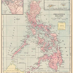
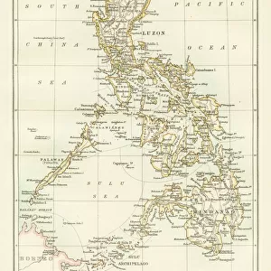
This print showcases a historic engraving of the "Map of the South China Sea, from the itinerary of La Perouse" dating back to 1787. Created by an anonymous French School artist in the 18th century, this intricate map provides a glimpse into the exploration and navigation routes taken by Jean François de Galaup, comte de Laperouse. Laperouse was a renowned French Navy officer and explorer whose ill-fated expedition mysteriously disappeared in Oceania. This remarkable engraving offers valuable insights into his journey through Asia's vast waters, specifically focusing on the South China Sea. The map highlights various coastal regions including those of China, Korea, and even parts of Southeast Asia such as the Philippines. With meticulous attention to detail, this historical artifact not only serves as a navigational guide but also captures the essence of adventure and discovery during that era. It allows us to appreciate Laperouse's courage and determination as he ventured into uncharted territories. Preserved within a private collection today, this engraving is a testament to human curiosity and exploration. As we gaze upon it, we are reminded of our innate desire to explore new horizons while acknowledging those who came before us in their quest for knowledge about our world's oceans.
MADE IN THE USA
Safe Shipping with 30 Day Money Back Guarantee
FREE PERSONALISATION*
We are proud to offer a range of customisation features including Personalised Captions, Color Filters and Picture Zoom Tools
SECURE PAYMENTS
We happily accept a wide range of payment options so you can pay for the things you need in the way that is most convenient for you
* Options may vary by product and licensing agreement. Zoomed Pictures can be adjusted in the Cart.