Home > Europe > United Kingdom > England > Oxfordshire > Oxford
Map of England, c.1900 (engraving)
")
![]()
Wall Art and Photo Gifts from Fine Art Finder
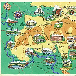
Map of England, c.1900 (engraving)
532917 Map of England, c.1900 (engraving); (add.info.: Map of England, with Oxford, Buckingham, Hertford, Essex, Middlesex, Berkshire, Hampshire, parts of Bedford and Wiltshire, circa 1902, from the 10th edition of Encyclopaedia Britannica.); Encyclopaedia Britannica/UIG
Media ID 38454206
© Encyclopaedia Britannica/UIG / Bridgeman Images
1902 19th Century Style Bedford Berkshire Buckingham Essex Guidance Hampshire Hertford Illustration Technique Meridian Middlesex Navigational Equipment Old Fashioned Oxfordshire Part Of Physical Geography The Past Western Script Wiltshire
FEATURES IN THESE COLLECTIONS
> Europe
> United Kingdom
> England
> Berkshire
> Related Images
> Europe
> United Kingdom
> England
> Essex
> Related Images
> Europe
> United Kingdom
> England
> Hampshire
> Related Images
> Europe
> United Kingdom
> England
> Maps
> Europe
> United Kingdom
> England
> Middlesex
> Related Images
> Europe
> United Kingdom
> England
> Oxford
> Europe
> United Kingdom
> England
> Oxfordshire
> Oxford
> Europe
> United Kingdom
> England
> Oxfordshire
> Related Images
> Europe
> United Kingdom
> England
> Paintings
> Europe
> United Kingdom
> England
> Wiltshire
> Related Images
> Fine Art Finder
> Temp Classification
EDITORS COMMENTS
This stunning engraving of a Map of England, circa 1900, offers a glimpse into the past with its intricate details and historical significance. The map showcases various counties including Oxford, Buckingham, Hertford, Essex, Middlesex, Berkshire, Hampshire, parts of Bedford and Wiltshire. It is a true representation of the cartography style of the 19th century.
As you study this map closely, you can see the old-fashioned charm in every line and curve. The Western script used for labeling adds to its authenticity and vintage appeal. This piece serves as both a navigational tool and a work of art that captures the essence of exploration during that time period.
The Map of England is not just about geography; it tells a story of how people traveled and explored new territories in search of knowledge and adventure. It symbolizes guidance and direction in an era where maps were essential for navigation on land and sea.
With no people present in the image, one can truly appreciate the beauty and complexity of this historical artifact. Whether you are interested in British history or simply admire fine craftsmanship, this print is sure to captivate your imagination with its rich heritage and cultural significance.
MADE IN THE USA
Safe Shipping with 30 Day Money Back Guarantee
FREE PERSONALISATION*
We are proud to offer a range of customisation features including Personalised Captions, Color Filters and Picture Zoom Tools
SECURE PAYMENTS
We happily accept a wide range of payment options so you can pay for the things you need in the way that is most convenient for you
* Options may vary by product and licensing agreement. Zoomed Pictures can be adjusted in the Cart.