Home > Europe > United Kingdom > England > London > Art > Paintings
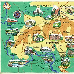
Map of England and Wales, c.1900 (engraving)
")
![]()
Wall Art and Photo Gifts from Fine Art Finder
Map of England and Wales, c.1900 (engraving)
532905 Map of England and Wales, c.1900 (engraving); (add.info.: Map of southern England and Wales, including insets of London and Vicinity, and the Isles of Sicily, circa 1902, from the 10th edition of Encyclopaedia Britannica.); Encyclopaedia Britannica/UIG
Media ID 38208534
© Encyclopaedia Britannica/UIG / Bridgeman Images
1902 19th Century Style Archipelago Guidance Illustration Technique Meridian Navigational Equipment Old Fashioned Part Of Physical Geography The Past Welsh Western Script
FEATURES IN THESE COLLECTIONS
> Europe
> Italy
> Sicily
> Related Images
> Europe
> United Kingdom
> England
> London
> Art
> Paintings
> Europe
> United Kingdom
> England
> London
> Fashion
> Europe
> United Kingdom
> England
> Maps
> Europe
> United Kingdom
> England
> Paintings
> Europe
> United Kingdom
> Maps
> Europe
> United Kingdom
> Paintings
> Europe
> United Kingdom
> Scotland
> Western Isles
> Related Images
> Europe
> United Kingdom
> Wales
> Maps
> Europe
> United Kingdom
> Wales
> Paintings
> Fine Art Finder
> Temp Classification
EDITORS COMMENTS
This stunning engraving of a Map of England and Wales, circa 1900, is a true masterpiece of cartography. The intricate details and elegant design showcase the skill and artistry of the mapmaker from over a century ago.
The map not only provides geographical information but also serves as a window into the past, offering insights into the political boundaries, topography, and landmarks of southern England and Wales during that time period. The insets of London and Vicinity, as well as the Isles of Sicily, add further depth to this historical representation.
As we gaze upon this vintage map, we are transported back to an era when navigational equipment was essential for exploration and discovery. The old-fashioned charm exuded by this piece evokes a sense of nostalgia for simpler times when maps were meticulously crafted works of art.
From the meridian lines to the sea routes depicted with precision, every detail on this map speaks volumes about the rich history and heritage of Great Britain. It serves as a reminder of how far we have come in terms of technological advancements while also highlighting the timeless beauty found in traditional illustration techniques.
This print is not just a visual delight but also an educational tool that offers valuable insights into physical geography and historical context. A true treasure for any history enthusiast or lover of antique artwork.
MADE IN THE USA
Safe Shipping with 30 Day Money Back Guarantee
FREE PERSONALISATION*
We are proud to offer a range of customisation features including Personalised Captions, Color Filters and Picture Zoom Tools
SECURE PAYMENTS
We happily accept a wide range of payment options so you can pay for the things you need in the way that is most convenient for you
* Options may vary by product and licensing agreement. Zoomed Pictures can be adjusted in the Cart.