Home > Europe > United Kingdom > England > Manchester > Northern Ireland
Map of Liverpool, Manchester, c.1900 (engraving)
")
![]()
Wall Art and Photo Gifts from Fine Art Finder
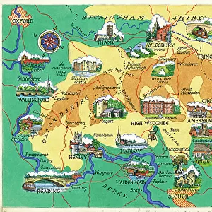
Map of Liverpool, Manchester, c.1900 (engraving)
533270 Map of Liverpool, Manchester, c.1900 (engraving); (add.info.: Map of Liverpool and Manchester, England, circa 1902, from the 10th edition of Encyclopaedia Britannica.); Encyclopaedia Britannica/UIG
Media ID 38310266
© Encyclopaedia Britannica/UIG / Bridgeman Images
1902 19th Century Style Cut Out Guidance Illustration Technique Irish Sea Liverpool Liverpudlian Manchester Navigational Equipment Old Fashioned Part Of Physical Geography The Past Western Script White Background Mersey River
FEATURES IN THESE COLLECTIONS
> Europe
> Republic of Ireland
> Maps
> Europe
> Republic of Ireland
> Paintings
> Europe
> United Kingdom
> England
> Liverpool
> Europe
> United Kingdom
> England
> Manchester
> Manchester
> Europe
> United Kingdom
> England
> Manchester
> Northern Ireland
> Europe
> United Kingdom
> England
> Maps
> Europe
> United Kingdom
> England
> Paintings
> Europe
> United Kingdom
> England
> Rivers
> Europe
> United Kingdom
> Maps
> Europe
> United Kingdom
> Northern Ireland
> Maps
> Fine Art Finder
> Temp Classification
EDITORS COMMENTS
This stunning engraving of a map of Liverpool and Manchester, circa 1900, captures the intricate details of these historic English cities. The delicate lines and precise labeling showcase the cartographic artistry of the time, providing a glimpse into the past when navigation relied on maps like these.
The map highlights key features such as the Mersey River flowing through both cities and their proximity to the Irish Sea. It serves as a valuable historical document, offering insight into the physical geography and layout of Liverpool and Manchester in the early 20th century.
As you study this vintage map, you can almost imagine yourself exploring these bustling urban centers during a bygone era. The old-fashioned charm exuded by this engraving evokes a sense of nostalgia for simpler times when maps were essential tools for travelers seeking guidance on their journeys.
Whether you have personal ties to Liverpool or Manchester or simply appreciate European history, this print is sure to captivate your imagination. Display it proudly in your home or office as a tribute to these iconic British cities and their rich cultural heritage.
MADE IN THE USA
Safe Shipping with 30 Day Money Back Guarantee
FREE PERSONALISATION*
We are proud to offer a range of customisation features including Personalised Captions, Color Filters and Picture Zoom Tools
SECURE PAYMENTS
We happily accept a wide range of payment options so you can pay for the things you need in the way that is most convenient for you
* Options may vary by product and licensing agreement. Zoomed Pictures can be adjusted in the Cart.