Home > Fine Art Storehouse > The Magical World of Illustration > Palmer Illustrated Collection
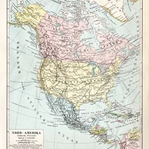
Map of the world horizontal projection 1856

![]()
Wall Art and Photo Gifts from Fine Art Storehouse
Map of the world horizontal projection 1856
Colton and Fitchs Modern School Geography by George W. Fitch - New York 1856
Unleash your creativity and transform your space into a visual masterpiece!
THEPALMER
Media ID 13612309
© Roberto A Sanchez
62990 Business Finance And Industry Cartographer Earth East East Asia Equator Line Globe Man Made Object Globe Navigational Equipment Hemisphere Planet Earth Space Time Zone Topography World Map Drawing Art Product
FEATURES IN THESE COLLECTIONS
> Fine Art Storehouse
> The Magical World of Illustration
> Palmer Illustrated Collection
> Fine Art Storehouse
> Map
> Historical Maps
EDITORS COMMENTS
This print showcases a remarkable piece of history - the "Map of the world horizontal projection 1856" from Colton and Fitch's Modern School Geography by George W. Fitch, published in New York in 1856. This antique cartographic illustration takes us back to a time when explorers embarked on daring adventures to map our vast planet. The intricate details captured in this engraving reveal the topography of different regions, including the equator line that divides our globe into two hemispheres. The map also highlights various time zones, providing insight into how people across the world experienced different moments simultaneously. As we gaze upon this stunning artwork, we are reminded of humanity's relentless curiosity about Earth and its diverse landscapes. It serves as a testament to mankind's continuous efforts to understand and navigate our planet. The craftsmanship involved in creating this map is truly awe-inspiring. Every contour and boundary has been meticulously drawn, showcasing both East Asia and other parts of the world with utmost precision. This drawing art product transports us back to an era when maps were not just navigational tools but works of art themselves. "The Map of the world horizontal projection 1856" invites us to appreciate Earth's beauty while acknowledging our place within it. As we explore every corner depicted on this historic artifact, let us marvel at how far we have come since its creation over a century ago – yet remain humbled by how much there still is left for us to discover about our incredible planet.
MADE IN THE USA
Safe Shipping with 30 Day Money Back Guarantee
FREE PERSONALISATION*
We are proud to offer a range of customisation features including Personalised Captions, Color Filters and Picture Zoom Tools
SECURE PAYMENTS
We happily accept a wide range of payment options so you can pay for the things you need in the way that is most convenient for you
* Options may vary by product and licensing agreement. Zoomed Pictures can be adjusted in the Cart.