Home > Fine Art Storehouse > The Magical World of Illustration > Palmer Illustrated Collection
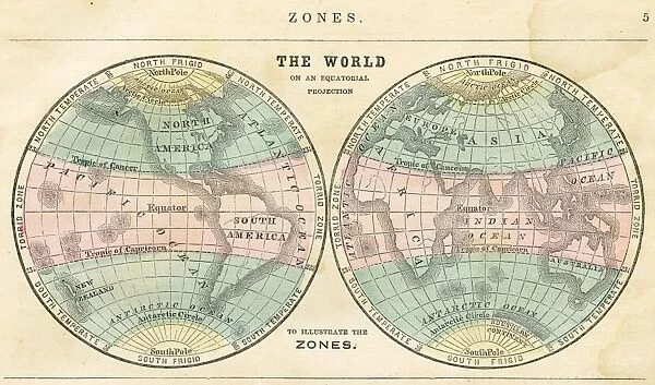
Map of the world in zones 1856
![]()

Wall Art and Photo Gifts from Fine Art Storehouse
Map of the world in zones 1856
Colton and Fitchs Modern School Geography by George W. Fitch - New York 1856
Unleash your creativity and transform your space into a visual masterpiece!
THEPALMER
Media ID 13612305
© Roberto A Sanchez
62990 Business Finance And Industry Cartographer Earth East East Asia Equator Line Globe Man Made Object Globe Navigational Equipment Hemisphere Planet Earth Space Time Zone Topography World Map Drawing Art Product
FEATURES IN THESE COLLECTIONS
> Fine Art Storehouse
> The Magical World of Illustration
> Palmer Illustrated Collection
> Fine Art Storehouse
> Map
> Historical Maps
EDITORS COMMENTS
This print showcases a remarkable piece of history - the "Map of the world in zones 1856" from Colton and Fitch's Modern School Geography by George W. Fitch, published in New York back in 1856. A true testament to the artistry and precision of cartographers from that era, this antique map is a treasure trove of information. The illustration beautifully captures the topography of our planet, showcasing continents, countries, and oceans with intricate detail. The equator line divides the globe into two hemispheres, while time zones are clearly marked for easy reference. This engraving serves as an invaluable resource for understanding physical geography on a global scale. As we gaze upon this stunning work of art, it transports us back to a time when maps were meticulously hand-drawn and engraved with utmost care. It reminds us that long before satellite imagery or GPS systems existed, cartographers played a crucial role in shaping our understanding of Earth's vastness. The horizontal composition allows us to fully appreciate every inch of this masterpiece. Its presence evokes curiosity about distant lands and ignites our sense of adventure. Whether used as navigational equipment or simply admired for its artistic merit, this map stands as a testament to human ingenuity and exploration. THEPALMER has skillfully captured not only the essence but also the historical significance behind this extraordinary map print – an exquisite addition to any space seeking to celebrate both art and knowledge simultaneously.
MADE IN THE USA
Safe Shipping with 30 Day Money Back Guarantee
FREE PERSONALISATION*
We are proud to offer a range of customisation features including Personalised Captions, Color Filters and Picture Zoom Tools
SECURE PAYMENTS
We happily accept a wide range of payment options so you can pay for the things you need in the way that is most convenient for you
* Options may vary by product and licensing agreement. Zoomed Pictures can be adjusted in the Cart.


