Home > Arts > Artists > O > Oceanic Oceanic
antique, archival, bay of bengal, border, cartography, country, document, geography

![]()
Wall Art and Photo Gifts from Fine Art Storehouse
antique, archival, bay of bengal, border, cartography, country, document, geography
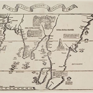
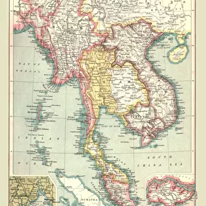
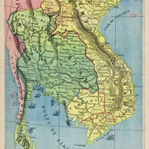
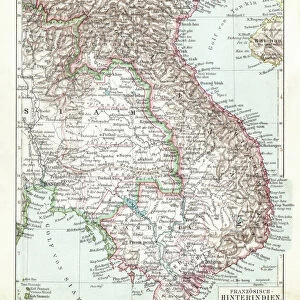
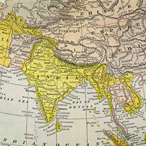
antique, archival, bay of bengal, border, cartography, country, document, geography, historic, historical, inaccurate, india, indian ocean, malaysia, map, nobody, peninsula, scale, text, thailand, vintage, words, Antique Maps, 87646385
Unleash your creativity and transform your space into a visual masterpiece!
Hemera Technologies
Media ID 15133642
© Getty Images
Border Country Document Geography India Indian Ocean Malaysia Peninsula Scale Text Thailand Words Bay Of Bengal Inaccurate
FEATURES IN THESE COLLECTIONS
> Arts
> Artists
> O
> Oceanic Oceanic
> Asia
> India
> Related Images
> Asia
> Malaysia
> Related Images
> Asia
> Thailand
> Related Images
> Asia
> Turkmenistan
> Maps
> Fine Art Storehouse
> Map
> Historical Maps
> Maps and Charts
> Early Maps
EDITORS COMMENTS
This print by Hemera Technologies takes us back in time with its antique charm and historical significance. The image showcases an archival map, rich in detail and character, depicting the Bay of Bengal region. With its intricate cartography, this document offers a glimpse into the geography of countries like India, Malaysia, and Thailand. The vintage appeal of this piece is evident through its aged texture and faded words that tell stories from a different era. While some inaccuracies may be present due to the limitations of past mapping techniques, it serves as a valuable testament to the evolution of our understanding of these lands. As we explore this antique map, we are transported to a time when borders were drawn differently and countries had their own unique identities. The peninsula juts out proudly into the Indian Ocean while text provides additional context for those curious about the history behind these regions. Whether you appreciate it as an art lover or a history enthusiast, this print invites you to delve into the past and marvel at how far our knowledge has come. It serves as a reminder that even imperfect representations can hold immense value in preserving our collective heritage.
MADE IN THE USA
Safe Shipping with 30 Day Money Back Guarantee
FREE PERSONALISATION*
We are proud to offer a range of customisation features including Personalised Captions, Color Filters and Picture Zoom Tools
SECURE PAYMENTS
We happily accept a wide range of payment options so you can pay for the things you need in the way that is most convenient for you
* Options may vary by product and licensing agreement. Zoomed Pictures can be adjusted in the Cart.