Home > Arts > Contemporary art > Digital artwork > Street art
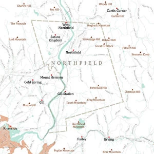
CT Litchfield Thomaston Vector Road Map

![]()
Wall Art and Photo Gifts from Fine Art Storehouse
CT Litchfield Thomaston Vector Road Map
CT Litchfield Thomaston Vector Road Map. All source data is in the public domain. U.S. Census Bureau Census Tiger. Used Layers: areawater, linearwater, roads, rails, cousub, pointlm, uac10
Unleash your creativity and transform your space into a visual masterpiece!
Frank Ramspott
Media ID 20687841
© Frank Ramspott, all rights reserved
City Map Computer Graphic Connecticut County Digital Composite District Geographical Border Litchfield Road Map Text Vector Village Black Rock Digitally Generated Image Hancock Northfield Thomaston Watertown
FEATURES IN THESE COLLECTIONS
> Animals
> Mammals
> Cats (Wild)
> Tiger
> Animals
> Mammals
> Muridae
> Water Mouse
> Arts
> Contemporary art
> Digital artwork
> Street art
> Arts
> Landscape paintings
> Waterfall and river artworks
> River artworks
> Arts
> Portraits
> Pop art gallery
> Street art portraits
> Arts
> Street art graffiti
> Digital art
> Digital paintings
> Europe
> France
> Lakes
> Related Images
> Fine Art Storehouse
> Map
> Reference Maps
> Maps and Charts
> Related Images
EDITORS COMMENTS
This print showcases the intricate details of the CT Litchfield Thomaston Vector Road Map, designed by Frank Ramspott. With a digitally generated image, this visually stunning piece captures the essence of cartography and geographical borders in Connecticut. The vibrant colors and precise lines bring to life the various elements of this map, including cities, towns, rivers, lakes, and villages. The artist skillfully combines layers such as areawater, linearwater, roads, rails, cousub, pointlm, and uac10 from public domain data provided by the U. S. Census Bureau Census Tiger. Every street name and landmark is meticulously included in this composition - Reynolds Bridge, Northfield Hickory Hill French Mountain Black Rock Mount Tobe Watertown Hancock - creating a comprehensive representation of the region. With no people present in this image but an abundance of textual information displayed throughout its entirety; it serves as both an aesthetic masterpiece and a functional tool for navigation purposes. This digital composite seamlessly merges physical geography with computer graphics to produce a high-quality work that is both informative and visually appealing. Whether you are fascinated by maps or have a connection to Connecticut's Litchfield Thomaston area specifically; this print offers an engaging perspective on its surroundings. It invites viewers to explore every corner of these interconnected streets while appreciating the artistry behind their creation.
MADE IN THE USA
Safe Shipping with 30 Day Money Back Guarantee
FREE PERSONALISATION*
We are proud to offer a range of customisation features including Personalised Captions, Color Filters and Picture Zoom Tools
SECURE PAYMENTS
We happily accept a wide range of payment options so you can pay for the things you need in the way that is most convenient for you
* Options may vary by product and licensing agreement. Zoomed Pictures can be adjusted in the Cart.