Home > North America > United States of America > Massachusetts > Worcester
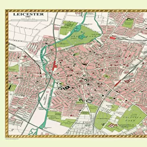
MA Worcester Spencer Vector Road Map

![]()
Wall Art and Photo Gifts from Fine Art Storehouse
MA Worcester Spencer Vector Road Map
MA Worcester Spencer Vector Road Map. All source data is in the public domain. U.S. Census Bureau Census Tiger. Used Layers: areawater, linearwater, roads, rails, cousub, pointlm, uac10
Unleash your creativity and transform your space into a visual masterpiece!
Frank Ramspott
Media ID 20691689
© Frank Ramspott, all rights reserved
City Map Computer Graphic County Digital Composite District Geographical Border Leicester Massachusetts Road Map Text Vector Worcester Digitally Generated Image Greenville Spencer
FEATURES IN THESE COLLECTIONS
> Animals
> Mammals
> Cats (Wild)
> Tiger
> Animals
> Mammals
> Muridae
> Water Mouse
> Arts
> Contemporary art
> Digital artwork
> Street art
> Arts
> Landscape paintings
> Waterfall and river artworks
> River artworks
> Arts
> Portraits
> Pop art gallery
> Street art portraits
> Arts
> Street art graffiti
> Digital art
> Digital paintings
> Fine Art Storehouse
> Map
> Reference Maps
> Maps and Charts
> Related Images
> North America
> United States of America
> Massachusetts
> Worcester
> Popular Themes
> Lake District
> Sport
> Football
> Soccer
> Leicester City
EDITORS COMMENTS
This vibrant and detailed print showcases the MA Worcester Spencer Vector Road Map, a true masterpiece of cartography. Created by Frank Ramspott, this digitally generated image captures the essence of Massachusetts' geography with precision and artistry. The map features various layers sourced from public domain data, including areawater, linearwater, roads, rails, cousub, pointlm, and uac10. Each element is meticulously incorporated to provide an accurate representation of the region's physical geography. With no people in sight, this color image focuses solely on the intricate details that make up this vector city map. From the winding rivers to expansive lakes and bustling streets - every feature is brought to life through computer graphics and digital composites. The geographical borders are clearly defined as they encompass cities like Worcester and Spencer along with smaller communities such as Tafts Corner, Hillsville, Upper Wire Village, Greenville, Leicester, and North Brookfield. This comprehensive depiction allows viewers to navigate effortlessly through these areas. Perfect for both decorative purposes or educational use alike, this print offers a visually captivating exploration into Massachusetts' urban landscape. Whether you're a cartography enthusiast or simply appreciate fine design, this artwork will undoubtedly add depth and beauty to any space it graces.
MADE IN THE USA
Safe Shipping with 30 Day Money Back Guarantee
FREE PERSONALISATION*
We are proud to offer a range of customisation features including Personalised Captions, Color Filters and Picture Zoom Tools
SECURE PAYMENTS
We happily accept a wide range of payment options so you can pay for the things you need in the way that is most convenient for you
* Options may vary by product and licensing agreement. Zoomed Pictures can be adjusted in the Cart.