Home > Arts > Street art graffiti > Digital art > Vector illustrations
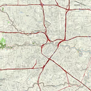
College Station Texas US City Street Map

![]()
Wall Art and Photo Gifts from Fine Art Storehouse
College Station Texas US City Street Map
Vector Illustration of a City Street Map of College Station, Texas, USA. Scale 1:60, 000.
All source data is in the public domain.
U.S. Geological Survey, US Topo
Used Layers:
USGS The National Map: National Hydrography Dataset (NHD)
USGS The National Map: National Transportation Dataset (NTD)
Unleash your creativity and transform your space into a visual masterpiece!
Frank Ramspott
Media ID 15192924
© Frank Ramspott, all rights reserved
Aerial View City Map Computer Graphic Directly Above Downtown District Gray Road Map Texas Text Digitally Generated Image Green Color White Color
FEATURES IN THESE COLLECTIONS
> Aerial Photography
> Related Images
> Animals
> Insects
> Hemiptera
> Green Scale
> Arts
> Contemporary art
> Digital artwork
> Street art
> Arts
> Landscape paintings
> Waterfall and river artworks
> River artworks
> Arts
> Portraits
> Pop art gallery
> Street art portraits
> Arts
> Street art graffiti
> Digital art
> Digital paintings
> Arts
> Street art graffiti
> Digital art
> Vector illustrations
> Fine Art Storehouse
> Map
> Street Maps
> Fine Art Storehouse
> Map
> USA Maps
> Maps and Charts
> Geological Map
> Maps and Charts
> Related Images
> North America
> United States of America
> Lakes
> Related Images
EDITORS COMMENTS
This print showcases a detailed and beautifully designed vector illustration of College Station, Texas, USA. With a scale of 1:60,000, this city street map provides an intricate depiction of the downtown district, including its bustling streets and vibrant landmarks. The image encompasses various elements such as lakes, rivers, roads, and bridges that contribute to the charm and character of this Texan town. The source data used for this artwork is in the public domain and comes from reputable sources like the U. S. Geological Survey's National Hydrography Dataset (NHD) and National Transportation Dataset (NTD). These layers ensure accuracy in representing the city's hydrography features as well as its comprehensive transportation network. Rendered with precision using computer graphics technology by Frank Ramspott, this digitally generated image offers an aerial view directly above College Station. The color palette incorporates shades of gray, blue, white, and green to enhance clarity while maintaining a visually appealing aesthetic. Perfect for enthusiasts of cartography or those with an affinity for their hometowns or favorite cities around the world alike; this art piece adds sophistication to any space without overwhelming it. Whether displayed in homes or offices, it serves as both a decorative element and a functional tool for navigation within College Station's urban landscape.
MADE IN THE USA
Safe Shipping with 30 Day Money Back Guarantee
FREE PERSONALISATION*
We are proud to offer a range of customisation features including Personalised Captions, Color Filters and Picture Zoom Tools
SECURE PAYMENTS
We happily accept a wide range of payment options so you can pay for the things you need in the way that is most convenient for you
* Options may vary by product and licensing agreement. Zoomed Pictures can be adjusted in the Cart.