Home > North America > United States of America > Arizona > Glendale
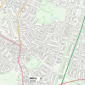
Glendale Arizona US City Street Map

![]()
Wall Art and Photo Gifts from Fine Art Storehouse
Glendale Arizona US City Street Map
Vector Illustration of a City Street Map of Glendale, Arizona, USA. Scale 1:60, 000.
All source data is in the public domain.
U.S. Geological Survey, US Topo
Used Layers:
USGS The National Map: National Hydrography Dataset (NHD)
USGS The National Map: National Transportation Dataset (NTD)
Unleash your creativity and transform your space into a visual masterpiece!
Frank Ramspott
Media ID 15055181
© Frank Ramspott, all rights reserved
Aerial View Arizona Computer Graphic Directly Above Gray Green Road Map Street Map Text Digitally Generated Image Glendale
FEATURES IN THESE COLLECTIONS
> Aerial Photography
> Related Images
> Animals
> Insects
> Hemiptera
> Green Scale
> Arts
> Contemporary art
> Digital artwork
> Street art
> Arts
> Landscape paintings
> Waterfall and river artworks
> River artworks
> Arts
> Portraits
> Pop art gallery
> Street art portraits
> Arts
> Street art graffiti
> Digital art
> Digital paintings
> Arts
> Street art graffiti
> Digital art
> Vector illustrations
> Fine Art Storehouse
> Map
> Street Maps
> Fine Art Storehouse
> Map
> USA Maps
> Maps and Charts
> Geological Map
> Maps and Charts
> Related Images
> North America
> United States of America
> Arizona
> Glendale
EDITORS COMMENTS
This print showcases a meticulously detailed city street map of Glendale, Arizona, USA. With a scale of 1:60,000, this vector illustration provides an intricate depiction of the city's layout and infrastructure. The artist, Frank Ramspott, has skillfully utilized various layers from public domain sources such as the U. S. Geological Survey and US Topo to create this visually stunning piece. The map incorporates essential elements like rivers, lakes, buildings, streets, roads, and even transportation networks to offer a comprehensive overview of Glendale. Its design is digitally generated with vibrant colors including shades of gray for roads and green for parks or open spaces. The aerial view perspective allows viewers to appreciate the physical geography of the area while providing a sense of direction within the city. With no people present in the image itself but accompanied by text indicating its origin and authorship information (Frank Ramspott), this print is both aesthetically pleasing and informative. It would make an excellent addition to any art collection or serve as a practical reference tool for residents or visitors exploring Glendale's urban landscape.
MADE IN THE USA
Safe Shipping with 30 Day Money Back Guarantee
FREE PERSONALISATION*
We are proud to offer a range of customisation features including Personalised Captions, Color Filters and Picture Zoom Tools
SECURE PAYMENTS
We happily accept a wide range of payment options so you can pay for the things you need in the way that is most convenient for you
* Options may vary by product and licensing agreement. Zoomed Pictures can be adjusted in the Cart.